Montluel night lights from space
Night Light of Montluel (Auvergne-Rhône-Alpes) from space (France) Src. Average luminocity for 10x10km area is 36.9375% and for 50x50km: 31.7199%.
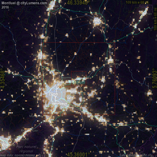
Analysis of Montluel night lights 2016
Square area 10x10 km:
 6.4%
6.4%90-99
6.99%80-89
3.13%70-79
4.76%60-69
1.79%50-59
3.87%40-49
3.72%30-39
7.74%20-29
19.2%10-19
31.4%0-9
11.01%Square area 50x50 km:
8.52%90-99
6.6%80-89
2.33%70-79
3.05%60-69
3.29%50-59
3.89%40-49
3.91%30-39
5.36%20-29
8.36%10-19
12.34%0-9
42.36%Clear (daylight) street map image can be seen on geolist.org.
Map coordinates:
46° 20' 22.1" North, 4° 21' 16.8" East
45° 51' 6.8" North, 5° 3' 28.1" East
45° 21' 36" North, 5° 45' 39.3" East
Some cities around Montluel sort by population:
• Vaulx-en-Velin
12.6 km =7.8 mi,  234°
234°
• Meyzieu
10.4 km =6.5 mi,  204°
204°
• Rillieux-la-Pape
12.8 km =8 mi,  252°
252°
• Décines-Charpieu
12 km =7.5 mi,  219°
219°
• Miribel
8.5 km =5.3 mi, 250°
• Charvieu-Chavagneux
13.4 km =8.3 mi,  147°
147°
• Meximieux
12.6 km =7.8 mi,  60°
60°
• Jonage
6.2 km =3.9 mi,  187°
187°
2992290 (p: 6,528)
Sources (retrieved 2019-11-25):
» Earth at Night: Flat Maps 2012, 2016