Sallaumines night lights from space
Night Light of Sallaumines (Hauts-de-France) from space (France) Src. Average luminocity for 10x10km area is 83.3081% and for 50x50km: 40.8491%.
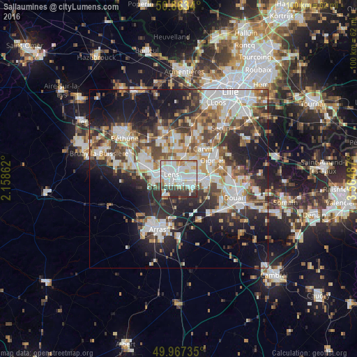
Analysis of Sallaumines night lights 2016
Square area 10x10 km:
 32.77%
90-99
32.63%80-89
6.72%70-79
4.34%60-69
3.64%50-59
1.4%40-49
3.36%30-39
13.17%20-29
1.96%10-19
0%0-9
0%Square area 50x50 km:
9.26%90-99
9.73%80-89
3.63%70-79
4.16%60-69
5.18%50-59
4.67%40-49
5.56%30-39
6.63%20-29
10.5%10-19
15.7%0-9
24.97%Clear (daylight) street map image can be seen on geolist.org.
Map coordinates:
50° 51' 48.2" North, 2° 9' 31" East
50° 25' 3" North, 2° 51' 42.3" East
49° 58' 2.5" North, 3° 33' 53.5" East
Some cities around Sallaumines sort by population:
• Lens
3 km =1.9 mi,  305°
305°
• Avion
2.3 km =1.4 mi,  250°
250°
• Méricourt
1.8 km =1.1 mi,  178°
178°
• Rouvroy
4.1 km =2.5 mi,  132°
132°
• Billy-Montigny
2.9 km =1.8 mi,  90°
90°
• Noyelles-sous-Lens
1.7 km =1.1 mi,  26°
26°
• Fouquières-lès-Lens
3.8 km =2.4 mi,  71°
71°
• Loison-sous-Lens
2.4 km =1.5 mi,  345°
345°
2976404 (p: 10,637)
Sources (retrieved 2019-11-25):
» Earth at Night: Flat Maps 2012, 2016