Fenain night lights from space
Night Light of Fenain (Hauts-de-France) from space (France) Src. Average luminocity for 10x10km area is 45.979% and for 50x50km: 33.4672%.
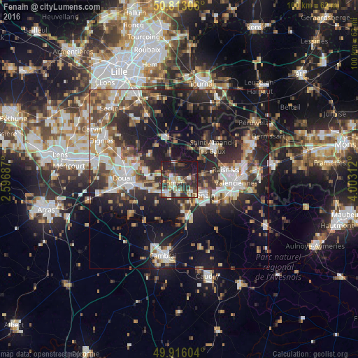
Analysis of Fenain night lights 2016
Square area 10x10 km:
 4.9%
4.9%90-99
8.96%80-89
5.74%70-79
3.64%60-69
6.16%50-59
6.44%40-49
10.08%30-39
11.48%20-29
27.45%10-19
15.13%0-9
0%Square area 50x50 km:
5.54%90-99
6.59%80-89
2.9%70-79
3.27%60-69
4.68%50-59
4.33%40-49
4.96%30-39
6.09%20-29
12.22%10-19
21.06%0-9
28.37%Clear (daylight) street map image can be seen on geolist.org.
Map coordinates:
50° 48' 47" North, 2° 35' 48.7" East
50° 22' 0" North, 3° 18' 0" East
49° 54' 57.7" North, 4° 0' 11.2" East
Some cities around Fenain sort by population:
• Denain
7.9 km =4.9 mi,  121°
121°
• Somain
1.6 km =1 mi,  239°
239°
• Douchy-les-Mines
9.8 km =6.1 mi,  138°
138°
• Aniche
5.3 km =3.3 mi,  218°
218°
• Escaudain
4.9 km =3 mi, 139°
• Pecquencourt
6.3 km =3.9 mi,  282°
282°
• Lallaing
9.6 km =6 mi,  285°
285°
• Wallers
6.6 km =4.1 mi,  82°
82°
3018739 (p: 5,346)
Sources (retrieved 2019-11-25):
» Earth at Night: Flat Maps 2012, 2016