Escaudain night lights from space
Night Light of Escaudain (Hauts-de-France) from space (France) Src. Average luminocity for 10x10km area is 54.5364% and for 50x50km: 30.0203%.
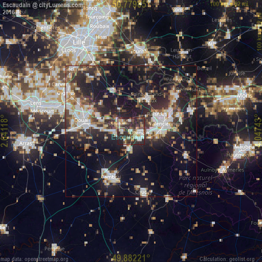
Analysis of Escaudain night lights 2016
Square area 10x10 km:
 8.12%
8.12%90-99
13.17%80-89
7%70-79
5.18%60-69
7.14%50-59
4.06%40-49
10.64%30-39
12.75%20-29
30.53%10-19
1.4%0-9
0%Square area 50x50 km:
4.71%90-99
5.74%80-89
2.62%70-79
2.46%60-69
3.92%50-59
3.95%40-49
4.5%30-39
5.79%20-29
11.39%10-19
21.62%0-9
33.3%Clear (daylight) street map image can be seen on geolist.org.
Map coordinates:
50° 46' 47.5" North, 2° 38' 28.2" East
50° 19' 59.3" North, 3° 20' 39.5" East
49° 52' 56" North, 4° 2' 50.7" East
Some cities around Escaudain sort by population:
• Denain
3.6 km =2.2 mi,  96°
96°
• Somain
5.4 km =3.4 mi,  303°
303°
• Douchy-les-Mines
5 km =3.1 mi,  136°
136°
• Aniche
6.5 km =4 mi,  266°
266°
• Trith-Saint-Léger
10 km =6.2 mi, 100°
• Wallers
5.7 km =3.5 mi,  36°
36°
• Fenain
4.9 km =3 mi,  319°
319°
• Petite-Forêt
10.5 km =6.5 mi,  69°
69°
3019827 (p: 9,479)
Sources (retrieved 2019-11-25):
» Earth at Night: Flat Maps 2012, 2016