Somain night lights from space
Night Light of Somain (Hauts-de-France) from space (France) Src. Average luminocity for 10x10km area is 48.7731% and for 50x50km: 33.4026%.
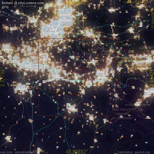
Analysis of Somain night lights 2016
Square area 10x10 km:
 6.16%
6.16%90-99
9.66%80-89
6.86%70-79
3.92%60-69
6.16%50-59
5.18%40-49
9.38%30-39
12.89%20-29
32.35%10-19
7.42%0-9
0%Square area 50x50 km:
5.57%90-99
6.66%80-89
3.03%70-79
3.36%60-69
4.54%50-59
4.33%40-49
4.9%30-39
5.9%20-29
12.04%10-19
20.3%0-9
29.37%Clear (daylight) street map image can be seen on geolist.org.
Map coordinates:
50° 48' 21.8" North, 2° 34' 40.7" East
50° 21' 34.6" North, 3° 16' 51.9" East
49° 54' 32.1" North, 3° 59' 3.2" East
Some cities around Somain sort by population:
• Denain
8.7 km =5.4 mi,  112°
112°
• Aniche
3.8 km =2.4 mi,  210°
210°
• Escaudain
5.4 km =3.4 mi,  123°
123°
• Pecquencourt
5.3 km =3.3 mi,  293°
293°
• Lallaing
8.6 km =5.3 mi, 293°
• Flines-lez-Raches
9.4 km =5.8 mi,  312°
312°
• Wallers
8 km =5 mi,  78°
78°
• Fenain
1.6 km =1 mi,  59°
59°
2974324 (p: 12,310)
Sources (retrieved 2019-11-25):
» Earth at Night: Flat Maps 2012, 2016