Wallers night lights from space
Night Light of Wallers (Hauts-de-France) from space (France) Src. Average luminocity for 10x10km area is 39.014% and for 50x50km: 30.3499%.
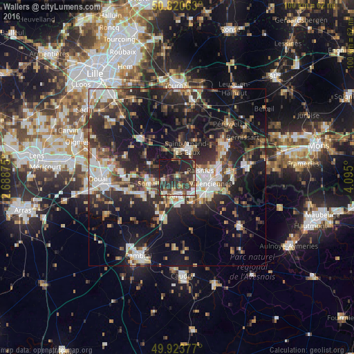
Analysis of Wallers night lights 2016
Square area 10x10 km:
100  3.22%
3.22%
90-99 5.74%
80-89 3.36%
70-79 2.52%
60-69 3.36%
50-59 5.88%
40-49 10.64%
30-39 17.23%
20-29 25.91%
10-19 21.85%
0-9 0.28%
3.22%90-99
5.74%80-89
3.36%70-79
2.52%60-69
3.36%50-59
5.88%40-49
10.64%30-39
17.23%20-29
25.91%10-19
21.85%0-9
0.28%Square area 50x50 km:
100 4.53%
90-99 5.66%
80-89 2.55%
70-79 2.54%
60-69 4.06%
50-59 3.8%
40-49 4.8%
30-39 5.99%
20-29 12.46%
10-19 22.39%
0-9 31.23%
4.53%90-99
5.66%80-89
2.55%70-79
2.54%60-69
4.06%50-59
3.8%40-49
4.8%30-39
5.99%20-29
12.46%10-19
22.39%0-9
31.23%Clear (daylight) street map image can be seen on geolist.org.
Map coordinates:
50° 49' 14.3" North, 2° 41' 19.5" East
50° 22' 27.6" North, 3° 23' 30.8" East
49° 55' 25.6" North, 4° 5' 42" East
Some cities around Wallers sort by population:
• Denain
5 km =3.1 mi,  178°
178°
• Anzin
7.9 km =4.9 mi,  91°
91°
• Raismes
6.6 km =4.1 mi,  81°
81°
• Somain
8 km =5 mi,  258°
258°
• Escaudain
5.7 km =3.5 mi,  216°
216°
• Beuvrages
7.3 km =4.5 mi, 81°
• Fenain
6.6 km =4.1 mi, 262°
• Petite-Forêt
6.5 km =4 mi,  97°
97°
2967494 (p: 5,546)
Sources (retrieved 2019-11-25):
» Earth at Night: Flat Maps 2012, 2016