La Bassée night lights from space
Night Light of La Bassée (Hauts-de-France) from space (France) Src. Average luminocity for 10x10km area is 58.0952% and for 50x50km: 46.1373%.
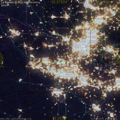
Analysis of La Bassée night lights 2016
Square area 10x10 km:
 10.36%
90-99
13.03%80-89
5.6%70-79
6.3%60-69
10.92%50-59
7.42%40-49
12.46%30-39
13.87%20-29
13.73%10-19
6.3%0-9
0%Square area 50x50 km:
11.68%90-99
10.63%80-89
4.07%70-79
4.98%60-69
5.6%50-59
5.33%40-49
6.11%30-39
7.44%20-29
10.46%10-19
14.99%0-9
18.72%Clear (daylight) street map image can be seen on geolist.org.
Map coordinates:
50° 58' 44.5" North, 2° 6' 11.1" East
50° 32' 3.3" North, 2° 48' 22.3" East
50° 5' 6.7" North, 3° 30' 33.6" East
Some cities around La Bassée sort by population:
• Annoeullin
8.9 km =5.5 mi,  93°
93°
• Beuvry
8.8 km =5.5 mi,  257°
257°
• Wingles
5.7 km =3.5 mi,  142°
142°
• Loos-en-Gohelle
8.6 km =5.3 mi,  186°
186°
• Vendin-le-Vieil
8 km =5 mi,  147°
147°
• Sainghin-en-Weppes
7.3 km =4.5 mi,  62°
62°
• Bauvin
6.5 km =4 mi,  107°
107°
• Douvrin
3.3 km =2.1 mi, 148°
3011307 (p: 6,027)
Sources (retrieved 2019-11-25):
» Earth at Night: Flat Maps 2012, 2016