Enghien-les-Bains night lights from space
Night Light of Enghien-les-Bains (Île-de-France) from space (France) Src. Average luminocity for 10x10km area is 98.0653% and for 50x50km: 67.2607%.
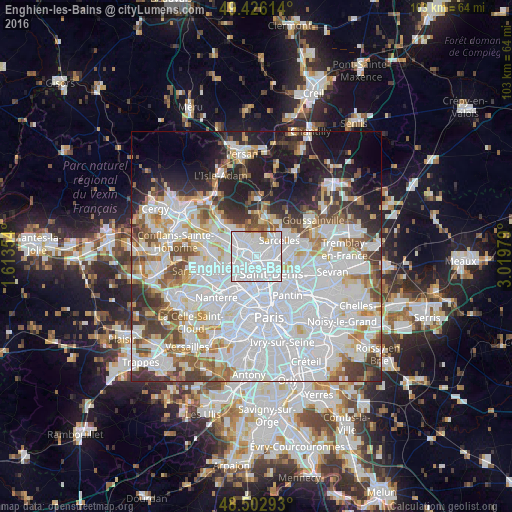
Analysis of Enghien-les-Bains night lights 2016
Square area 10x10 km:
 73.86%
90-99
20.88%80-89
0.99%70-79
1.7%60-69
2.27%50-59
0.28%40-49
0%30-39
0%20-29
0%10-19
0%0-9
0%Square area 50x50 km:
31.76%90-99
15.69%80-89
4.82%70-79
4.22%60-69
5.11%50-59
4.69%40-49
4.96%30-39
5.06%20-29
6.16%10-19
9.95%0-9
7.59%Clear (daylight) street map image can be seen on geolist.org.
Map coordinates:
49° 25' 34.1" North, 1° 36' 48.7" East
48° 58' 0" North, 2° 19' 0" East
48° 30' 10.5" North, 3° 1' 11.2" East
Some cities around Enghien-les-Bains sort by population:
• Épinay-sur-Seine
1.5 km =0.9 mi,  184°
184°
• Villeneuve-la-Garenne
3 km =1.9 mi, 182°
• Deuil-la-Barre
1.4 km =0.9 mi,  34°
34°
• Montmorency
3.1 km =1.9 mi,  39°
39°
• Saint-Gratien
2.3 km =1.4 mi,  289°
289°
• Soisy-sous-Montmorency
2.6 km =1.6 mi,  335°
335°
• Montmagny
2.3 km =1.4 mi,  71°
71°
• Villetaneuse
2 km =1.2 mi,  116°
116°
3020188 (p: 10,951)
Sources (retrieved 2019-11-25):
» Earth at Night: Flat Maps 2012, 2016