Villetaneuse night lights from space
Night Light of Villetaneuse (Île-de-France) from space (France) Src. Average luminocity for 10x10km area is 98.8082% and for 50x50km: 68.2234%.
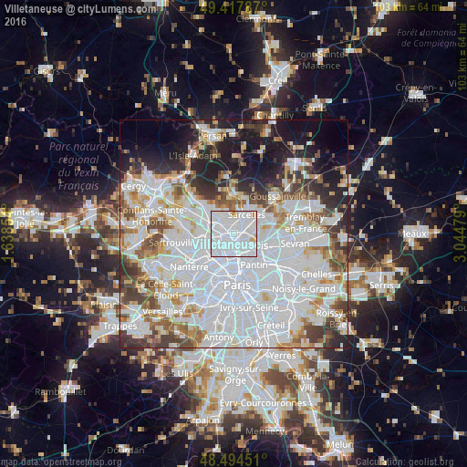
Analysis of Villetaneuse night lights 2016
Square area 10x10 km:
 77.13%
90-99
18.61%80-89
2.56%70-79
0.85%60-69
0.85%50-59
0%40-49
0%30-39
0%20-29
0%10-19
0%0-9
0%Square area 50x50 km:
32.08%90-99
16.02%80-89
4.92%70-79
4.42%60-69
5.26%50-59
4.61%40-49
5.16%30-39
5.18%20-29
6.24%10-19
9.38%0-9
6.72%Clear (daylight) street map image can be seen on geolist.org.
Map coordinates:
49° 25' 4.3" North, 1° 38' 18.7" East
48° 57' 30" North, 2° 20' 30" East
48° 29' 40.2" North, 3° 2' 41.2" East
Some cities around Villetaneuse sort by population:
• Saint-Denis
2.7 km =1.7 mi,  160°
160°
• Épinay-sur-Seine
2 km =1.2 mi,  254°
254°
• Stains
3.2 km =2 mi,  106°
106°
• Pierrefitte-sur-Seine
1.7 km =1.1 mi,  55°
55°
• Deuil-la-Barre
2.3 km =1.4 mi,  332°
332°
• Montmagny
1.7 km =1.1 mi,  12°
12°
• Enghien-les-Bains
2 km =1.2 mi,  296°
296°
• Groslay
3.1 km =1.9 mi, 7°
2968275 (p: 12,025)
Sources (retrieved 2019-11-25):
» Earth at Night: Flat Maps 2012, 2016