Cormontreuil night lights from space
Night Light of Cormontreuil (Grand Est) from space (France) Src. Average luminocity for 10x10km area is 56.4719% and for 50x50km: 8.8038%.
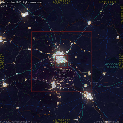
Analysis of Cormontreuil night lights 2016
Square area 10x10 km:
 28.48%
90-99
12.7%80-89
2.54%70-79
0.67%60-69
1.2%50-59
1.47%40-49
4.28%30-39
4.41%20-29
18.58%10-19
22.19%0-9
3.48%Square area 50x50 km:
2.18%90-99
1.58%80-89
0.62%70-79
0.7%60-69
0.42%50-59
0.82%40-49
0.93%30-39
1.07%20-29
2.93%10-19
6.77%0-9
81.98%Clear (daylight) street map image can be seen on geolist.org.
Map coordinates:
49° 40' 25.8" North, 3° 20' 48.7" East
49° 13' 0" North, 4° 3' 0" East
48° 45' 18.9" North, 4° 45' 11.2" East
Some cities around Cormontreuil sort by population:
• Reims
5.6 km =3.5 mi,  343°
343°
• Châlons-en-Champagne
37.2 km =23.1 mi,  141°
141°
• Épernay
20.7 km =12.9 mi,  198°
198°
• Tinqueux
6.1 km =3.8 mi,  307°
307°
• Bétheny
7.6 km =4.7 mi,  2°
2°
• Saint-Memmie
38.1 km =23.7 mi, 140°
• Mourmelon-le-Grand
24.7 km =15.3 mi,  112°
112°
• Fismes
28.3 km =17.6 mi,  290°
290°
3023628 (p: 6,479)
Sources (retrieved 2019-11-25):
» Earth at Night: Flat Maps 2012, 2016