Mourmelon-le-Grand night lights from space
Night Light of Mourmelon-le-Grand (Grand Est) from space (France) Src. Average luminocity for 10x10km area is 8.7591% and for 50x50km: 6.731%.
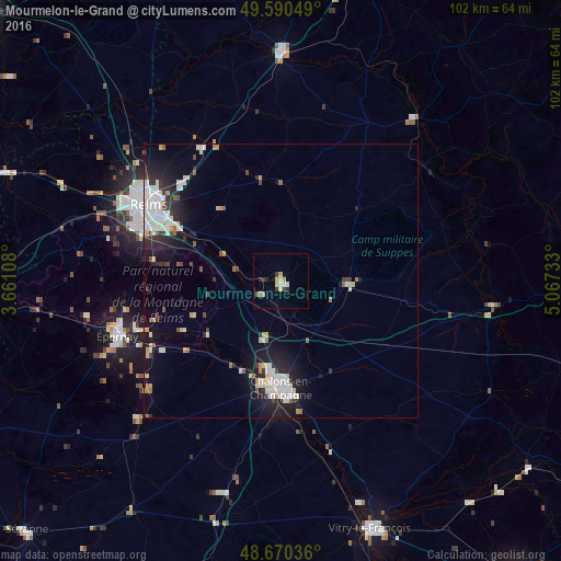
Analysis of Mourmelon-le-Grand night lights 2016
Square area 10x10 km:
 1.12%
1.12%90-99
0.56%80-89
1.54%70-79
2.8%60-69
0.14%50-59
0%40-49
1.12%30-39
1.82%20-29
1.54%10-19
0.56%0-9
88.8%Square area 50x50 km:
1.66%90-99
1.31%80-89
0.61%70-79
0.6%60-69
0.36%50-59
0.45%40-49
0.55%30-39
0.72%20-29
1.97%10-19
4.72%0-9
87.05%Clear (daylight) street map image can be seen on geolist.org.
Map coordinates:
49° 35' 25.8" North, 3° 39' 39.9" East
49° 7' 57.2" North, 4° 21' 51.1" East
48° 40' 13.3" North, 5° 4' 2.4" East
Some cities around Mourmelon-le-Grand sort by population:
• Reims
28.5 km =17.7 mi,  301°
301°
• Châlons-en-Champagne
19.9 km =12.4 mi,  179°
179°
• Épernay
31.2 km =19.4 mi,  250°
250°
• Tinqueux
30.6 km =19 mi, 295°
• Cormontreuil
24.7 km =15.3 mi,  292°
292°
• Bétheny
28.1 km =17.5 mi,  307°
307°
• Saint-Memmie
20.1 km =12.5 mi, 175°
• Sainte-Menehould
39.1 km =24.3 mi,  96°
96°
2991413 (p: 5,829)
Sources (retrieved 2019-11-25):
» Earth at Night: Flat Maps 2012, 2016