Saint-Fons night lights from space
Night Light of Saint-Fons (Auvergne-Rhône-Alpes) from space (France) Src. Average luminocity for 10x10km area is 94.2773% and for 50x50km: 35.9264%.
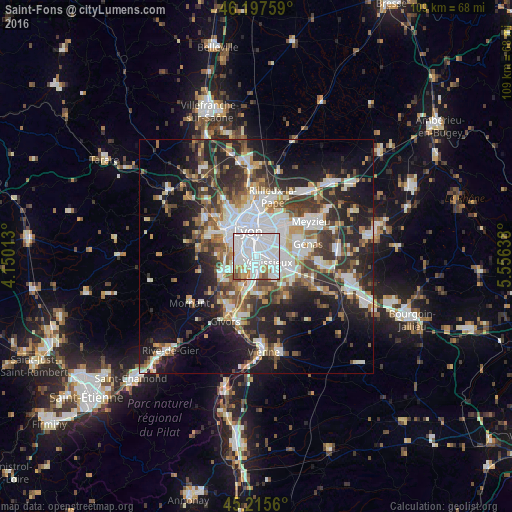
Analysis of Saint-Fons night lights 2016
Square area 10x10 km:
 61.36%
90-99
22.88%80-89
2.27%70-79
5%60-69
3.94%50-59
2.58%40-49
1.97%30-39
0%20-29
0%10-19
0%0-9
0%Square area 50x50 km:
8.88%90-99
7.46%80-89
2.71%70-79
3.69%60-69
3.85%50-59
4.58%40-49
4.82%30-39
5.74%20-29
11.05%10-19
14.63%0-9
32.59%Clear (daylight) street map image can be seen on geolist.org.
Map coordinates:
46° 11' 51.3" North, 4° 9' 0.5" East
45° 42' 31.5" North, 4° 51' 11.7" East
45° 12' 56.2" North, 5° 33' 23" East
Some cities around Saint-Fons sort by population:
• Lyon
4.4 km =2.7 mi,  353°
353°
• Vénissieux
2.9 km =1.8 mi,  117°
117°
• Bron
5.7 km =3.5 mi,  54°
54°
• Oullins
3.6 km =2.2 mi,  279°
279°
• Pierre-Bénite
2.3 km =1.4 mi,  255°
255°
• Feyzin
4 km =2.5 mi,  173°
173°
• Irigny
4.6 km =2.9 mi,  211°
211°
• La Mulatière
3.9 km =2.4 mi,  304°
304°
2980097 (p: 16,053)
Sources (retrieved 2019-11-25):
» Earth at Night: Flat Maps 2012, 2016