Irigny night lights from space
Night Light of Irigny (Auvergne-Rhône-Alpes) from space (France) Src. Average luminocity for 10x10km area is 79.9621% and for 50x50km: 34.852%.
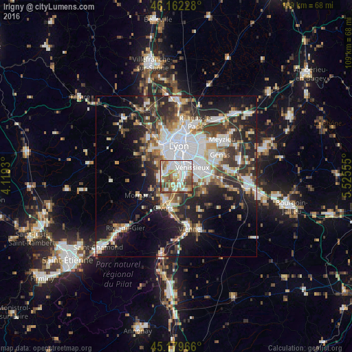
Analysis of Irigny night lights 2016
Square area 10x10 km:
 26.52%
90-99
24.55%80-89
7.12%70-79
6.36%60-69
11.82%50-59
11.06%40-49
9.55%30-39
2.73%20-29
0.3%10-19
0%0-9
0%Square area 50x50 km:
8.82%90-99
7.4%80-89
2.61%70-79
3.6%60-69
3.7%50-59
4.4%40-49
4.54%30-39
5.5%20-29
9.64%10-19
14.4%0-9
35.4%Clear (daylight) street map image can be seen on geolist.org.
Map coordinates:
46° 9' 44.2" North, 4° 7' 9.5" East
45° 40' 23.3" North, 4° 49' 20.7" East
45° 10' 46.8" North, 5° 31' 32" East
Some cities around Irigny sort by population:
• Vénissieux
5.6 km =3.5 mi,  61°
61°
• Oullins
4.7 km =2.9 mi,  345°
345°
• Saint-Genis-Laval
3.4 km =2.1 mi,  317°
317°
• Saint-Fons
4.6 km =2.9 mi,  31°
31°
• Brignais
5.3 km =3.3 mi,  270°
270°
• Pierre-Bénite
3.4 km =2.1 mi,  2°
2°
• Corbas
6.2 km =3.9 mi,  95°
95°
• Feyzin
2.8 km =1.7 mi,  90°
90°
3012742 (p: 8,869)
Sources (retrieved 2019-11-25):
» Earth at Night: Flat Maps 2012, 2016