Clisson night lights from space
Night Light of Clisson (Pays de la Loire) from space (France) Src. Average luminocity for 10x10km area is 11.0142% and for 50x50km: 11.1667%.
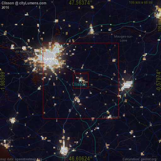
Analysis of Clisson night lights 2016
Square area 10x10 km:
 0.71%
0.71%90-99
0.99%80-89
0.57%70-79
0.85%60-69
1.14%50-59
2.7%40-49
4.55%30-39
2.84%20-29
0.99%10-19
0.85%0-9
83.81%Square area 50x50 km:
3.11%90-99
2.3%80-89
0.69%70-79
1.06%60-69
1.42%50-59
1.47%40-49
1.45%30-39
1.32%20-29
2.08%10-19
2.8%0-9
82.31%Clear (daylight) street map image can be seen on geolist.org.
Map coordinates:
47° 33' 49.5" North, 1° 59' 9.6" West
47° 5' 13.7" North, 1° 16' 58.3" West
46° 36' 22.5" North, 0° 34' 47.1" West
Some cities around Clisson sort by population:
• Vertou
16.8 km =10.4 mi,  302°
302°
• Basse-Goulaine
19.7 km =12.2 mi,  314°
314°
• Vallet
8.4 km =5.2 mi,  8°
8°
• Saint-Julien-de-Concelles
20 km =12.4 mi,  337°
337°
• Les Sorinières
19.8 km =12.3 mi,  290°
290°
• Le Loroux-Bottereau
17.5 km =10.9 mi, 343°
• Haute-Goulaine
16.7 km =10.4 mi,  318°
318°
• Montaigu
12.4 km =7.7 mi,  188°
188°
3024578 (p: 6,480)
Sources (retrieved 2019-11-25):
» Earth at Night: Flat Maps 2012, 2016