Vallet night lights from space
Night Light of Vallet (Pays de la Loire) from space (France) Src. Average luminocity for 10x10km area is 3.2426% and for 50x50km: 11.0371%.
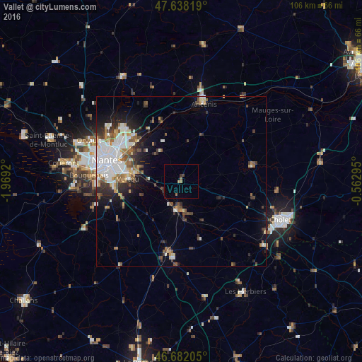
Analysis of Vallet night lights 2016
Square area 10x10 km:
 0%
0%90-99
0%80-89
0%70-79
0.3%60-69
1.49%50-59
0.6%40-49
0.6%30-39
0.74%20-29
0.45%10-19
0.15%0-9
95.68%Square area 50x50 km:
2.91%90-99
2.11%80-89
0.73%70-79
0.99%60-69
1.32%50-59
1.43%40-49
1.47%30-39
1.35%20-29
2.28%10-19
4.03%0-9
81.37%Clear (daylight) street map image can be seen on geolist.org.
Map coordinates:
47° 38' 17.5" North, 1° 58' 9.1" West
47° 9' 44.2" North, 1° 15' 57.9" West
46° 40' 55.4" North, 0° 33' 46.6" West
Some cities around Vallet sort by population:
• Saint-Sébastien-sur-Loire
18.6 km =11.6 mi,  285°
285°
• Vertou
15.4 km =9.6 mi,  272°
272°
• Basse-Goulaine
16.2 km =10.1 mi, 289°
• Thouaré-sur-Loire
17.6 km =10.9 mi,  312°
312°
• Saint-Julien-de-Concelles
13.5 km =8.4 mi,  318°
318°
• Clisson
8.4 km =5.2 mi,  188°
188°
• Le Loroux-Bottereau
10.5 km =6.5 mi, 323°
• Haute-Goulaine
13 km =8.1 mi, 288°
2970923 (p: 7,483)
Sources (retrieved 2019-11-25):
» Earth at Night: Flat Maps 2012, 2016