Haute-Goulaine night lights from space
Night Light of Haute-Goulaine (Pays de la Loire) from space (France) Src. Average luminocity for 10x10km area is 35.6458% and for 50x50km: 15.3999%.
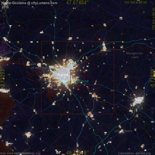
Analysis of Haute-Goulaine night lights 2016
Square area 10x10 km:
 4.17%
4.17%90-99
5.06%80-89
4.91%70-79
2.98%60-69
9.08%50-59
7.74%40-49
8.04%30-39
4.17%20-29
8.18%10-19
15.33%0-9
30.36%Square area 50x50 km:
3.8%90-99
2.93%80-89
1.11%70-79
1.49%60-69
1.93%50-59
1.95%40-49
2.02%30-39
1.93%20-29
3.61%10-19
6.82%0-9
72.41%Clear (daylight) street map image can be seen on geolist.org.
Map coordinates:
47° 40' 28.7" North, 2° 7' 57.1" West
47° 11' 56.6" North, 1° 25' 45.9" West
46° 43' 9" North, 0° 43' 34.6" West
Some cities around Haute-Goulaine sort by population:
• Rezé
9.3 km =5.8 mi,  257°
257°
• Saint-Sébastien-sur-Loire
5.7 km =3.5 mi,  279°
279°
• Vertou
4.5 km =2.8 mi,  221°
221°
• Sainte-Luce-sur-Loire
7.4 km =4.6 mi,  325°
325°
• Basse-Goulaine
3.2 km =2 mi,  296°
296°
• Thouaré-sur-Loire
7.8 km =4.8 mi,  355°
355°
• Saint-Julien-de-Concelles
6.9 km =4.3 mi,  29°
29°
• Le Loroux-Bottereau
7.4 km =4.6 mi,  54°
54°
3013766 (p: 5,290)
Sources (retrieved 2019-11-25):
» Earth at Night: Flat Maps 2012, 2016