Basse-Goulaine night lights from space
Night Light of Basse-Goulaine (Pays de la Loire) from space (France) Src. Average luminocity for 10x10km area is 61.1548% and for 50x50km: 15.6187%.
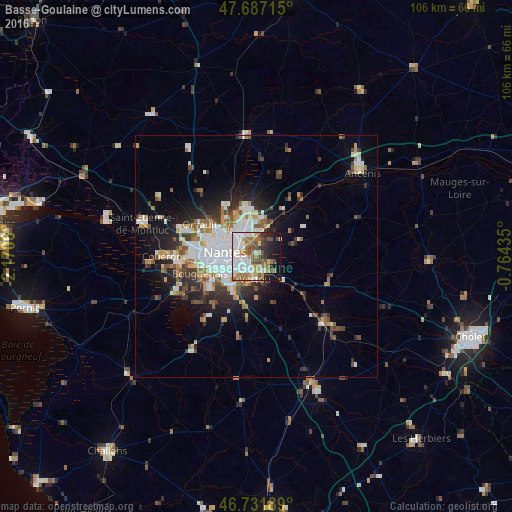
Analysis of Basse-Goulaine night lights 2016
Square area 10x10 km:
 17.41%
90-99
15.33%80-89
4.91%70-79
4.61%60-69
12.35%50-59
8.04%40-49
8.04%30-39
4.02%20-29
7.44%10-19
15.03%0-9
2.83%Square area 50x50 km:
3.86%90-99
3%80-89
1.13%70-79
1.54%60-69
1.91%50-59
1.91%40-49
1.95%30-39
1.95%20-29
3.66%10-19
6.81%0-9
72.28%Clear (daylight) street map image can be seen on geolist.org.
Map coordinates:
47° 41' 13.7" North, 2° 10' 14.2" West
47° 12' 42" North, 1° 28' 2.9" West
46° 43' 54.8" North, 0° 45' 51.7" West
Some cities around Basse-Goulaine sort by population:
• Nantes
6.5 km =4 mi,  275°
275°
• Rezé
7.1 km =4.4 mi,  241°
241°
• Saint-Sébastien-sur-Loire
2.7 km =1.7 mi,  260°
260°
• Vertou
4.8 km =3 mi,  181°
181°
• Sainte-Luce-sur-Loire
4.9 km =3 mi,  344°
344°
• Thouaré-sur-Loire
6.7 km =4.2 mi,  19°
19°
• Saint-Julien-de-Concelles
7.8 km =4.8 mi,  53°
53°
• Haute-Goulaine
3.2 km =2 mi,  116°
116°
3034699 (p: 8,160)
Sources (retrieved 2019-11-25):
» Earth at Night: Flat Maps 2012, 2016