Bourg-la-Reine night lights from space
Night Light of Bourg-la-Reine (Île-de-France) from space (France) Src. Average luminocity for 10x10km area is 99.2116% and for 50x50km: 75.2765%.
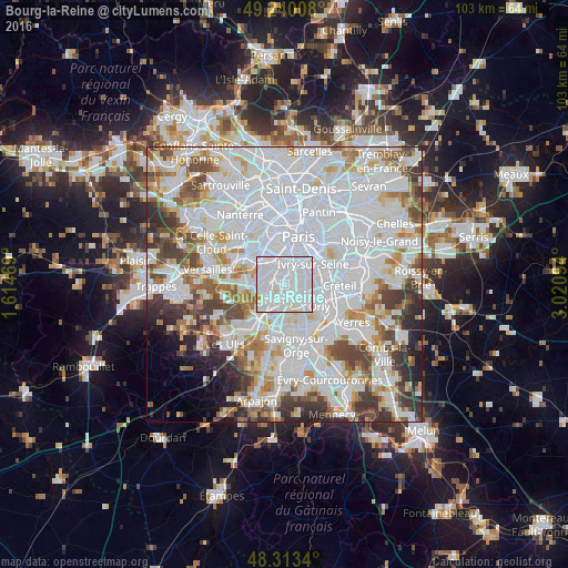
Analysis of Bourg-la-Reine night lights 2016
Square area 10x10 km:
 73.01%
90-99
25%80-89
1.42%70-79
0.57%60-69
0%50-59
0%40-49
0%30-39
0%20-29
0%10-19
0%0-9
0%Square area 50x50 km:
35.93%90-99
19.16%80-89
5.42%70-79
5.05%60-69
5.74%50-59
4.73%40-49
5.96%30-39
5.16%20-29
4.25%10-19
2.84%0-9
5.76%Clear (daylight) street map image can be seen on geolist.org.
Map coordinates:
49° 14' 24.3" North, 1° 36' 52.9" East
48° 46' 44" North, 2° 19' 4.1" East
48° 18' 48.2" North, 3° 1' 15.4" East
Some cities around Bourg-la-Reine sort by population:
• Bagneux
2 km =1.2 mi,  338°
338°
• L'Haÿ-les-Roses
1.2 km =0.7 mi,  66°
66°
• Cachan
2.4 km =1.5 mi,  35°
35°
• Fresnes
2.6 km =1.6 mi,  172°
172°
• Fontenay-aux-Roses
2.4 km =1.5 mi,  311°
311°
• Sceaux
2 km =1.2 mi,  262°
262°
• Chevilly-Larue
2.9 km =1.8 mi,  123°
123°
• Arcueil
2.6 km =1.6 mi,  24°
24°
3030990 (p: 18,870)
Sources (retrieved 2019-11-25):
» Earth at Night: Flat Maps 2012, 2016