Castelnaudary night lights from space
Night Light of Castelnaudary (Occitanie) from space (France) Src. Average luminocity for 10x10km area is 10.9985% and for 50x50km: 2.5513%.
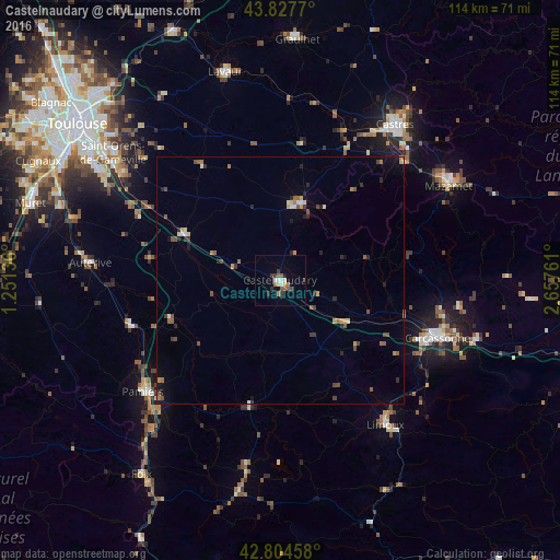
Analysis of Castelnaudary night lights 2016
Square area 10x10 km:
 0.76%
0.76%90-99
1.97%80-89
0.91%70-79
0.61%60-69
1.97%50-59
2.58%40-49
0.91%30-39
2.73%20-29
1.36%10-19
0.61%0-9
85.61%Square area 50x50 km:
0.09%90-99
0.25%80-89
0.31%70-79
0.3%60-69
0.37%50-59
0.47%40-49
0.52%30-39
0.42%20-29
0.71%10-19
0.45%0-9
96.11%Clear (daylight) street map image can be seen on geolist.org.
Map coordinates:
43° 49' 39.7" North, 1° 15' 4.9" East
43° 19' 5.8" North, 1° 57' 16.2" East
42° 48' 16.5" North, 2° 39' 27.4" East
Some cities around Castelnaudary sort by population:
• Carcassonne
34.2 km =21.3 mi,  109°
109°
• Pamiers
35.8 km =22.2 mi,  231°
231°
• Mazamet
38.8 km =24.1 mi,  60°
60°
• Limoux
36.4 km =22.6 mi,  143°
143°
• Revel
16.1 km =10 mi,  14°
14°
• Auterive
38.7 km =24 mi,  275°
275°
• Escalquens
38.9 km =24.2 mi,  304°
304°
• Labruguière
35 km =21.7 mi,  45°
45°
3028351 (p: 12,432)
Sources (retrieved 2019-11-25):
» Earth at Night: Flat Maps 2012, 2016