Mazamet night lights from space
Night Light of Mazamet (Occitanie) from space (France) Src. Average luminocity for 10x10km area is 19.6508% and for 50x50km: 4.2928%.
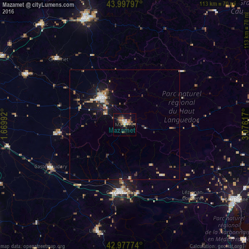
Analysis of Mazamet night lights 2016
Square area 10x10 km:
 0.95%
0.95%90-99
1.59%80-89
2.54%70-79
4.29%60-69
2.06%50-59
2.7%40-49
6.83%30-39
2.54%20-29
3.17%10-19
11.9%0-9
61.43%Square area 50x50 km:
0.32%90-99
0.54%80-89
0.49%70-79
0.52%60-69
0.6%50-59
0.66%40-49
0.68%30-39
0.69%20-29
0.98%10-19
3.12%0-9
91.4%Clear (daylight) street map image can be seen on geolist.org.
Map coordinates:
43° 59' 52.7" North, 1° 40' 11.7" East
43° 29' 24" North, 2° 22' 22.9" East
42° 58' 39.9" North, 3° 4' 34.2" East
Some cities around Mazamet sort by population:
• Carcassonne
30.8 km =19.1 mi,  183°
183°
• Castres
16.8 km =10.4 mi,  320°
320°
• Graulhet
43.6 km =27.1 mi,  314°
314°
• Castelnaudary
38.8 km =24.1 mi,  240°
240°
• Revel
29.9 km =18.6 mi,  263°
263°
• Aussillon
1.5 km =0.9 mi,  343°
343°
• Trèbes
31.6 km =19.6 mi,  169°
169°
• Labruguière
10.3 km =6.4 mi,  301°
301°
2994902 (p: 11,479)
Sources (retrieved 2019-11-25):
» Earth at Night: Flat Maps 2012, 2016