Auterive night lights from space
Night Light of Auterive (Occitanie) from space (France) Src. Average luminocity for 10x10km area is 10.5667% and for 50x50km: 11.8552%.
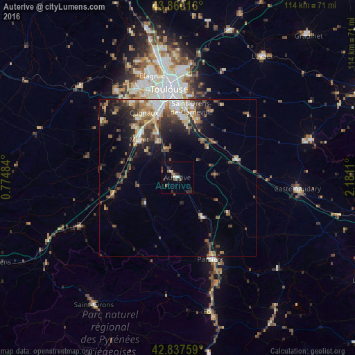
Analysis of Auterive night lights 2016
Square area 10x10 km:
 1.27%
1.27%90-99
1.27%80-89
0.63%70-79
0.63%60-69
1.27%50-59
2.22%40-49
1.59%30-39
1.59%20-29
5.4%10-19
1.27%0-9
82.86%Square area 50x50 km:
1.4%90-99
1.9%80-89
1.27%70-79
1.31%60-69
1.75%50-59
2%40-49
2.34%30-39
2.17%20-29
3.38%10-19
5.37%0-9
77.1%Clear (daylight) street map image can be seen on geolist.org.
Map coordinates:
43° 51' 36.6" North, 0° 46' 29.4" East
43° 21' 3.7" North, 1° 28' 40.7" East
42° 50' 15.3" North, 2° 10' 52" East
Some cities around Auterive sort by population:
• Muret
17.3 km =10.7 mi,  314°
314°
• Ramonville-Saint-Agne
21.7 km =13.5 mi,  359°
359°
• Castanet-Tolosan
18.4 km =11.4 mi,  5°
5°
• Portet-sur-Garonne
20 km =12.4 mi,  343°
343°
• Seysses
21.2 km =13.2 mi,  320°
320°
• Frouzins
22 km =13.7 mi,  325°
325°
• Escalquens
19.6 km =12.2 mi,  19°
19°
• Labarthe-sur-Lèze
12.9 km =8 mi, 330°
3035970 (p: 7,369)
Sources (retrieved 2019-11-25):
» Earth at Night: Flat Maps 2012, 2016