Luc-la-Primaube night lights from space
Night Light of Luc-la-Primaube (Occitanie) from space (France) Src. Average luminocity for 10x10km area is 17.754% and for 50x50km: 3.5299%.
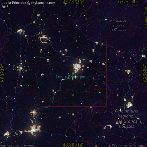
Analysis of Luc-la-Primaube night lights 2016
Square area 10x10 km:
 1.75%
1.75%90-99
2.54%80-89
2.38%70-79
0.63%60-69
1.43%50-59
4.29%40-49
3.02%30-39
3.49%20-29
2.86%10-19
19.84%0-9
57.78%Square area 50x50 km:
0.27%90-99
0.59%80-89
0.49%70-79
0.2%60-69
0.38%50-59
0.71%40-49
0.44%30-39
0.76%20-29
0.95%10-19
2.31%0-9
92.91%Clear (daylight) street map image can be seen on geolist.org.
Map coordinates:
44° 48' 55.2" North, 1° 49' 56.6" East
44° 18' 51.8" North, 2° 32' 7.9" East
43° 48' 32.9" North, 3° 14' 19.1" East
Some cities around Luc-la-Primaube sort by population:
• Rodez
5.2 km =3.2 mi,  35°
35°
• Millau
49.5 km =30.8 mi,  119°
119°
• Villefranche-de-Rouergue
39.9 km =24.8 mi,  275°
275°
• Figeac
51.7 km =32.1 mi,  309°
309°
• Carmaux
42 km =26.1 mi,  225°
225°
• Saint-Affrique
48.9 km =30.4 mi,  144°
144°
• Decazeville
35.5 km =22.1 mi,  320°
320°
• Saint-Juéry
47.8 km =29.7 mi,  212°
212°
2997262 (p: 5,267)
Sources (retrieved 2019-11-25):
» Earth at Night: Flat Maps 2012, 2016