Saint-Cyr-l’École night lights from space
Night Light of Saint-Cyr-l’École (Île-de-France) from space (France) Src. Average luminocity for 10x10km area is 74.6676% and for 50x50km: 57.4045%.
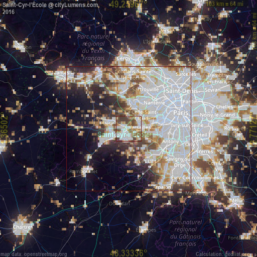
Analysis of Saint-Cyr-l’École night lights 2016
Square area 10x10 km:
 20.6%
20.6%90-99
21.73%80-89
7.67%70-79
4.69%60-69
13.07%50-59
9.52%40-49
13.07%30-39
9.66%20-29
0%10-19
0%0-9
0%Square area 50x50 km:
24.23%90-99
13.97%80-89
4.45%70-79
4.22%60-69
4.96%50-59
4.19%40-49
5.27%30-39
4.4%20-29
5.92%10-19
8.83%0-9
19.56%Clear (daylight) street map image can be seen on geolist.org.
Map coordinates:
49° 15' 34.8" North, 1° 21' 54.1" East
48° 47' 55.1" North, 2° 4' 5.3" East
48° 20' 0.1" North, 2° 46' 16.6" East
Some cities around Saint-Cyr-l’École sort by population:
• Versailles
4.9 km =3 mi,  83°
83°
• Montigny-le-Bretonneux
4.4 km =2.7 mi,  214°
214°
• Guyancourt
2.8 km =1.7 mi,  171°
171°
• Le Chesnay
4.7 km =2.9 mi,  56°
56°
• Trappes
4.6 km =2.9 mi,  233°
233°
• Voisins-le-Bretonneux
4.7 km =2.9 mi,  195°
195°
• Bois-d’Arcy
3.3 km =2.1 mi,  271°
271°
• Fontenay-le-Fleury
2.1 km =1.3 mi,  317°
317°
2980942 (p: 16,365)
Sources (retrieved 2019-11-25):
» Earth at Night: Flat Maps 2012, 2016