Bouguenais night lights from space
Night Light of Bouguenais (Pays de la Loire) from space (France) Src. Average luminocity for 10x10km area is 66.6875% and for 50x50km: 15.204%.
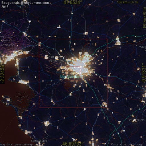
Analysis of Bouguenais night lights 2016
Square area 10x10 km:
 23.51%
90-99
12.65%80-89
5.21%70-79
7.59%60-69
8.04%50-59
8.93%40-49
7.29%30-39
11.46%20-29
12.05%10-19
3.27%0-9
0%Square area 50x50 km:
3.84%90-99
2.95%80-89
1.11%70-79
1.51%60-69
1.91%50-59
1.8%40-49
1.86%30-39
1.83%20-29
3.61%10-19
6.68%0-9
72.9%Clear (daylight) street map image can be seen on geolist.org.
Map coordinates:
47° 39' 12.2" North, 2° 19' 28.4" West
47° 10' 39.4" North, 1° 37' 17.1" West
46° 41' 51.1" North, 0° 55' 5.9" West
Some cities around Bouguenais sort by population:
• Nantes
6.8 km =4.2 mi,  49°
49°
• Saint-Herblain
4.9 km =3 mi,  335°
335°
• Rezé
5.4 km =3.4 mi,  85°
85°
• Couëron
8.6 km =5.3 mi,  298°
298°
• Les Sorinières
7.7 km =4.8 mi,  115°
115°
• La Montagne
4.7 km =2.9 mi,  282°
282°
• Bouaye
6.7 km =4.2 mi,  234°
234°
• Pont-Saint-Martin
6.6 km =4.1 mi,  155°
155°
3031268 (p: 16,824)
Sources (retrieved 2019-11-25):
» Earth at Night: Flat Maps 2012, 2016