La Montagne night lights from space
Night Light of La Montagne (Pays de la Loire) from space (France) Src. Average luminocity for 10x10km area is 49.0446% and for 50x50km: 14.6386%.
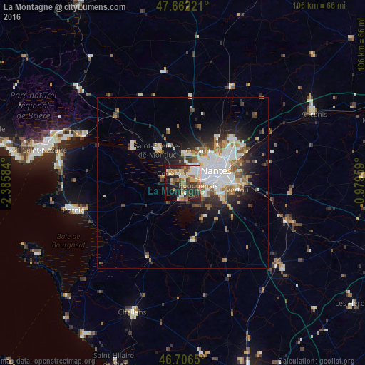
Analysis of La Montagne night lights 2016
Square area 10x10 km:
 8.33%
8.33%90-99
7.89%80-89
6.85%70-79
7.29%60-69
6.99%50-59
7.44%40-49
8.78%30-39
7.74%20-29
16.52%10-19
15.92%0-9
6.25%Square area 50x50 km:
3.79%90-99
2.84%80-89
1.06%70-79
1.45%60-69
1.88%50-59
1.62%40-49
1.78%30-39
1.72%20-29
3.54%10-19
6.6%0-9
73.71%Clear (daylight) street map image can be seen on geolist.org.
Map coordinates:
47° 39' 44" North, 2° 23' 9" West
47° 11' 11.4" North, 1° 40' 57.8" West
46° 42' 23.4" North, 0° 58' 46.5" West
Some cities around La Montagne sort by population:
• Nantes
10.4 km =6.5 mi,  70°
70°
• Saint-Herblain
4.3 km =2.7 mi,  36°
36°
• Rezé
10.1 km =6.3 mi,  93°
93°
• Couëron
4.3 km =2.7 mi,  317°
317°
• Bouguenais
4.7 km =2.9 mi,  102°
102°
• Sautron
8.5 km =5.3 mi,  5°
5°
• Bouaye
4.9 km =3 mi,  189°
189°
• Pont-Saint-Martin
10.2 km =6.3 mi,  133°
133°
3008096 (p: 6,012)
Sources (retrieved 2019-11-25):
» Earth at Night: Flat Maps 2012, 2016