Bouaye night lights from space
Night Light of Bouaye (Pays de la Loire) from space (France) Src. Average luminocity for 10x10km area is 19.1293% and for 50x50km: 14.4003%.
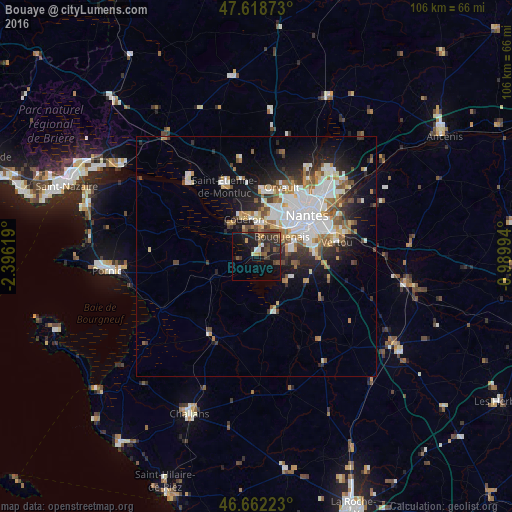
Analysis of Bouaye night lights 2016
Square area 10x10 km:
 0.71%
0.71%90-99
1.14%80-89
0.43%70-79
2.27%60-69
2.13%50-59
4.4%40-49
4.55%30-39
6.68%20-29
10.23%10-19
20.45%0-9
47.02%Square area 50x50 km:
3.77%90-99
2.81%80-89
1.09%70-79
1.42%60-69
1.86%50-59
1.63%40-49
1.63%30-39
1.59%20-29
3.53%10-19
6.56%0-9
74.1%Clear (daylight) street map image can be seen on geolist.org.
Map coordinates:
47° 37' 7.4" North, 2° 23' 46.3" West
47° 8' 33.5" North, 1° 41' 35" West
46° 39' 44" North, 0° 59' 23.8" West
Some cities around Bouaye sort by population:
• Saint-Herblain
9 km =5.6 mi,  22°
22°
• Rezé
11.7 km =7.3 mi,  68°
68°
• Couëron
8.3 km =5.2 mi,  344°
344°
• Bouguenais
6.7 km =4.2 mi,  54°
54°
• Les Sorinières
12.4 km =7.7 mi,  87°
87°
• La Montagne
4.9 km =3 mi,  9°
9°
• La Chevrolière
8.5 km =5.3 mi,  132°
132°
• Pont-Saint-Martin
8.5 km =5.3 mi,  104°
104°
3031403 (p: 5,673)
Sources (retrieved 2019-11-25):
» Earth at Night: Flat Maps 2012, 2016