Croissy-sur-Seine night lights from space
Night Light of Croissy-sur-Seine (Île-de-France) from space (France) Src. Average luminocity for 10x10km area is 89.8551% and for 50x50km: 64.7877%.
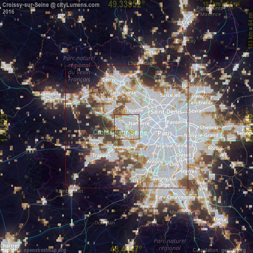
Analysis of Croissy-sur-Seine night lights 2016
Square area 10x10 km:
 34.8%
34.8%90-99
33.52%80-89
7.67%70-79
11.79%60-69
7.53%50-59
2.41%40-49
2.27%30-39
0%20-29
0%10-19
0%0-9
0%Square area 50x50 km:
28.65%90-99
15.43%80-89
4.78%70-79
4.57%60-69
5.2%50-59
4.47%40-49
5.69%30-39
4.92%20-29
7.59%10-19
10.29%0-9
8.4%Clear (daylight) street map image can be seen on geolist.org.
Map coordinates:
49° 20' 22.3" North, 1° 26' 6.8" East
48° 52' 45.3" North, 2° 8' 18.1" East
48° 24' 52.9" North, 2° 50' 29.3" East
Some cities around Croissy-sur-Seine sort by population:
• Rueil-Malmaison
3.8 km =2.4 mi,  94°
94°
• Chatou
1.9 km =1.2 mi,  51°
51°
• La Celle-Saint-Cloud
3.3 km =2.1 mi,  171°
171°
• Le Vésinet
1.6 km =1 mi,  345°
345°
• Le Pecq
3 km =1.9 mi,  301°
301°
• Montesson
3.3 km =2.1 mi,  358°
358°
• Bougival
1.9 km =1.2 mi, 173°
• Louveciennes
2.7 km =1.7 mi,  220°
220°
3022380 (p: 10,751)
Sources (retrieved 2019-11-25):
» Earth at Night: Flat Maps 2012, 2016