Le Vésinet night lights from space
Night Light of Le Vésinet (Île-de-France) from space (France) Src. Average luminocity for 10x10km area is 87.7415% and for 50x50km: 63.3911%.
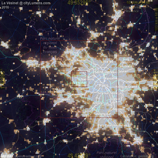
Analysis of Le Vésinet night lights 2016
Square area 10x10 km:
 33.52%
90-99
32.53%80-89
6.11%70-79
11.08%60-69
5.54%50-59
5.82%40-49
5.4%30-39
0%20-29
0%10-19
0%0-9
0%Square area 50x50 km:
27.87%90-99
14.94%80-89
4.7%70-79
4.36%60-69
5.19%50-59
4.4%40-49
5.6%30-39
4.95%20-29
7.64%10-19
11.35%0-9
8.99%Clear (daylight) street map image can be seen on geolist.org.
Map coordinates:
49° 21' 10.7" North, 1° 25' 47.9" East
48° 53' 34.1" North, 2° 7' 59.1" East
48° 25' 42.2" North, 2° 50' 10.4" East
Some cities around Le Vésinet sort by population:
• Saint-Germain-en-Laye
3.1 km =1.9 mi,  277°
277°
• Chatou
1.9 km =1.2 mi,  100°
100°
• Le Pecq
2.1 km =1.3 mi,  271°
271°
• Montesson
1.9 km =1.2 mi,  10°
10°
• Carrières-sur-Seine
3.7 km =2.3 mi,  65°
65°
• Croissy-sur-Seine
1.6 km =1 mi,  165°
165°
• Bougival
3.5 km =2.2 mi, 169°
• Louveciennes
3.8 km =2.4 mi,  200°
200°
2998854 (p: 16,740)
Sources (retrieved 2019-11-25):
» Earth at Night: Flat Maps 2012, 2016