Ruokolahti night lights from space
Night Light of Ruokolahti (South Karelia) from space (Finland) Src. Average luminocity for 10x10km area is 27.8347% and for 50x50km: 8.129%.
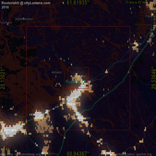
Analysis of Ruokolahti night lights 2016
Square area 10x10 km:
 2.27%
2.27%90-99
4.65%80-89
2.17%70-79
3.31%60-69
8.47%50-59
3.72%40-49
0%30-39
5.37%20-29
12.5%10-19
22.21%0-9
35.33%Square area 50x50 km:
1.13%90-99
1.53%80-89
0.74%70-79
0.83%60-69
1.57%50-59
1.31%40-49
0.62%30-39
1.19%20-29
2.71%10-19
5.22%0-9
83.15%Clear (daylight) street map image can be seen on geolist.org.
Map coordinates:
61° 37' 9.7" North, 28° 7' 48.8" East
61° 16' 60" North, 28° 49' 60" East
60° 56' 37.2" North, 29° 32' 11.3" East
Some cities around Ruokolahti sort by population:
• Vyborg, RU
64.2 km =39.9 mi,  183°
183°
• Lappeenranta
42.6 km =26.5 mi,  234°
234°
• Imatra
13.1 km =8.1 mi,  199°
199°
• Savonlinna
65.3 km =40.6 mi,  2°
2°
• Svetogorsk, RU
19.1 km =11.9 mi, 175°
• Joutseno
25.3 km =15.7 mi,  223°
223°
• Kamennogorsk, RU
40 km =24.9 mi,  156°
156°
• Kerimäki
73.7 km =45.8 mi,  18°
18°
638803 (p: 5,780)
Sources (retrieved 2019-11-25):
» Earth at Night: Flat Maps 2012, 2016