Pola de Laviana night lights from space
Night Light of Pola de Laviana (Asturias) from space (Spain) Src. Average luminocity for 10x10km area is 16.5303% and for 50x50km: 9.5998%.
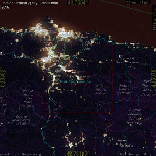
Analysis of Pola de Laviana night lights 2016
Square area 10x10 km:
 2.42%
2.42%90-99
2.42%80-89
0.3%70-79
1.82%60-69
1.21%50-59
2.58%40-49
2.27%30-39
4.39%20-29
5.45%10-19
11.21%0-9
65.91%Square area 50x50 km:
1.32%90-99
1.5%80-89
0.58%70-79
0.95%60-69
0.9%50-59
2.06%40-49
0.86%30-39
1.89%20-29
4.04%10-19
8.83%0-9
77.06%Clear (daylight) street map image can be seen on geolist.org.
Map coordinates:
43° 45' 19.4" North, 6° 15' 57.7" West
43° 14' 43.4" North, 5° 33' 46.4" West
42° 43' 51.8" North, 4° 51' 35.2" West
Some cities around Pola de Laviana sort by population:
• Oviedo
26.1 km =16.2 mi,  299°
299°
• Sama
11.3 km =7 mi, 299°
• Mieres
16.5 km =10.3 mi,  271°
271°
• Villaviciosa
28.2 km =17.5 mi,  21°
21°
• Lugones
26.7 km =16.6 mi,  310°
310°
• Ruayer
21.3 km =13.2 mi,  177°
177°
• Piloña
19.7 km =12.2 mi,  53°
53°
• El entrego
7.7 km =4.8 mi, 307°
3113271 (p: 14,210)
Sources (retrieved 2019-11-25):
» Earth at Night: Flat Maps 2012, 2016