Porto do Son night lights from space
Night Light of Porto do Son (Galicia) from space (Spain) Src. Average luminocity for 10x10km area is 11.9576% and for 50x50km: 11.2217%.
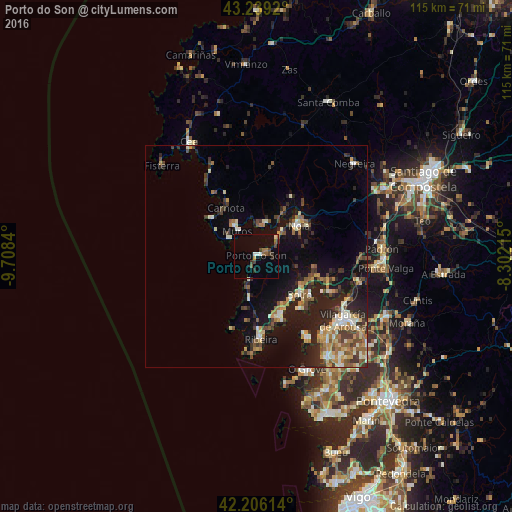
Analysis of Porto do Son night lights 2016
Square area 10x10 km:
 0.45%
0.45%90-99
1.82%80-89
0.45%70-79
0.76%60-69
1.52%50-59
1.82%40-49
2.58%30-39
2.58%20-29
1.52%10-19
4.09%0-9
82.42%Square area 50x50 km:
0.66%90-99
1.94%80-89
1.26%70-79
1.31%60-69
1.75%50-59
1.56%40-49
1.85%30-39
1.69%20-29
3.79%10-19
8.48%0-9
75.71%Clear (daylight) street map image can be seen on geolist.org.
Map coordinates:
43° 14' 21.1" North, 9° 42' 30.2" West
42° 43' 29.4" North, 9° 0' 19" West
42° 12' 22.1" North, 8° 18' 7.7" West
Some cities around Porto do Son sort by population:
• Santa Uxía de Ribeira
19.1 km =11.9 mi,  176°
176°
• Boiro
13.1 km =8.1 mi,  131°
131°
• Rianxo
17.5 km =10.9 mi,  118°
118°
• Muros
7.3 km =4.5 mi,  321°
321°
• A Pobra do Caramiñal
14.6 km =9.1 mi,  157°
157°
• Outes
17.4 km =10.8 mi,  28°
28°
• Carnota
12.9 km =8 mi,  327°
327°
• Illa de Arousa
20.9 km =13 mi,  148°
148°
3108716 (p: 9,613)
Sources (retrieved 2019-11-25):
» Earth at Night: Flat Maps 2012, 2016