Boiro night lights from space
Night Light of Boiro (Galicia) from space (Spain) Src. Average luminocity for 10x10km area is 33.6864% and for 50x50km: 20.3737%.
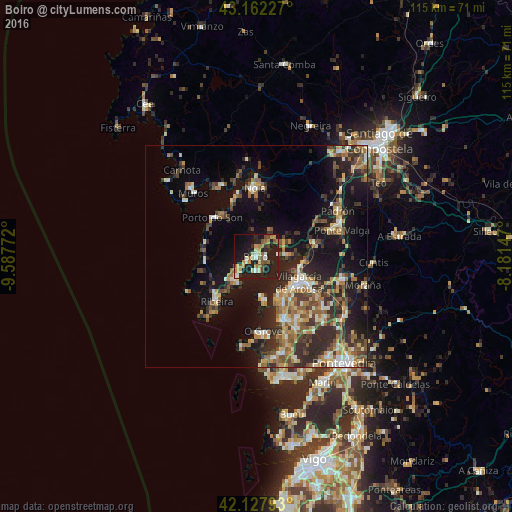
Analysis of Boiro night lights 2016
Square area 10x10 km:
 2.27%
2.27%90-99
4.55%80-89
4.85%70-79
4.39%60-69
7.58%50-59
3.33%40-49
4.39%30-39
1.52%20-29
10.76%10-19
46.67%0-9
9.7%Square area 50x50 km:
1.27%90-99
3.49%80-89
2.29%70-79
2.58%60-69
3.44%50-59
3.25%40-49
3.15%30-39
3.92%20-29
7.5%10-19
14.92%0-9
54.21%Clear (daylight) street map image can be seen on geolist.org.
Map coordinates:
43° 9' 44.2" North, 9° 35' 15.8" West
42° 38' 50.1" North, 8° 53' 4.5" West
42° 7' 40.5" North, 8° 10' 53.3" West
Some cities around Boiro sort by population:
• Vilagarcía de Arousa
11.4 km =7.1 mi,  119°
119°
• Santa Uxía de Ribeira
13.6 km =8.5 mi,  219°
219°
• Cambados
16.1 km =10 mi,  158°
158°
• Rianxo
5.5 km =3.4 mi,  87°
87°
• Vilanova de Arousa
10.4 km =6.5 mi,  153°
153°
• Porto do Son
13.1 km =8.1 mi,  311°
311°
• A Pobra do Caramiñal
6.6 km =4.1 mi, 221°
• Illa de Arousa
9.3 km =5.8 mi,  173°
173°
3127889 (p: 18,883)
Sources (retrieved 2019-11-25):
» Earth at Night: Flat Maps 2012, 2016