Carnota night lights from space
Night Light of Carnota (Galicia) from space (Spain) Src. Average luminocity for 10x10km area is 11.1667% and for 50x50km: 5.7865%.
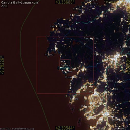
Analysis of Carnota night lights 2016
Square area 10x10 km:
 0.3%
0.3%90-99
2.58%80-89
1.67%70-79
0.61%60-69
1.82%50-59
0.61%40-49
1.82%30-39
2.73%20-29
1.52%10-19
0.76%0-9
85.61%Square area 50x50 km:
0.26%90-99
0.88%80-89
0.53%70-79
0.47%60-69
0.88%50-59
0.67%40-49
1.11%30-39
0.89%20-29
2.13%10-19
4.71%0-9
87.49%Clear (daylight) street map image can be seen on geolist.org.
Map coordinates:
43° 20' 12.7" North, 9° 47' 32.1" West
42° 49' 23.9" North, 9° 5' 20.9" West
42° 18' 19.6" North, 8° 23' 9.6" West
Some cities around Carnota sort by population:
• Boiro
25.7 km =16 mi,  139°
139°
• Muros
5.7 km =3.5 mi,  155°
155°
• Porto do Son
12.9 km =8 mi,  147°
147°
• A Pobra do Caramiñal
27.4 km =17 mi, 153°
• Outes
15.9 km =9.9 mi,  74°
74°
• Cee
16.7 km =10.4 mi,  331°
331°
• Mazaricos
16.1 km =10 mi,  36°
36°
• Fisterra
16.8 km =10.4 mi,  302°
302°
3126254 (p: 5,171)
Sources (retrieved 2019-11-25):
» Earth at Night: Flat Maps 2012, 2016