Fene night lights from space
Night Light of Fene (Galicia) from space (Spain) Src. Average luminocity for 10x10km area is 38.4317% and for 50x50km: 18.266%.
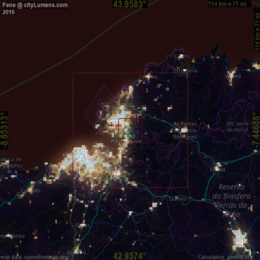
Analysis of Fene night lights 2016
Square area 10x10 km:
100  5.56%
5.56%
90-99 7.78%
80-89 3.65%
70-79 3.97%
60-69 3.49%
50-59 12.06%
40-49 5.71%
30-39 4.6%
20-29 14.29%
10-19 14.92%
0-9 23.97%
5.56%90-99
7.78%80-89
3.65%70-79
3.97%60-69
3.49%50-59
12.06%40-49
5.71%30-39
4.6%20-29
14.29%10-19
14.92%0-9
23.97%Square area 50x50 km:
100 2.68%
90-99 3.27%
80-89 1.52%
70-79 1.96%
60-69 3%
50-59 3.41%
40-49 3.57%
30-39 3.26%
20-29 6.13%
10-19 7.56%
0-9 63.65%
2.68%90-99
3.27%80-89
1.52%70-79
1.96%60-69
3%50-59
3.41%40-49
3.57%30-39
3.26%20-29
6.13%10-19
7.56%0-9
63.65%Clear (daylight) street map image can be seen on geolist.org.
Map coordinates:
43° 57' 29.9" North, 8° 51' 11.3" West
43° 27' 0" North, 8° 9' 0" West
42° 56' 14.6" North, 7° 26' 48.8" West
Some cities around Fene sort by population:
• Ferrol
7.1 km =4.4 mi,  308°
308°
• Narón
6.6 km =4.1 mi,  330°
330°
• Sada
13.6 km =8.5 mi,  219°
219°
• Valdoviño
16.7 km =10.4 mi,  4°
4°
• Bergondo
16.3 km =10.1 mi,  204°
204°
• Mugardos
8.6 km =5.3 mi,  277°
277°
• Ares
7.8 km =4.8 mi,  253°
253°
• Miño
11.8 km =7.3 mi, 199°
3122564 (p: 14,165)
Sources (retrieved 2019-11-25):
» Earth at Night: Flat Maps 2012, 2016