Ares night lights from space
Night Light of Ares (Galicia) from space (Spain) Src. Average luminocity for 10x10km area is 40.0317% and for 50x50km: 20.2611%.
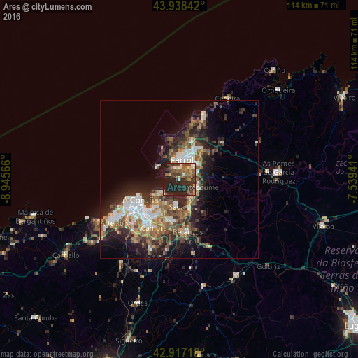
Analysis of Ares night lights 2016
Square area 10x10 km:
100  1.75%
1.75%
90-99 4.76%
80-89 3.02%
70-79 4.44%
60-69 7.46%
50-59 11.75%
40-49 9.68%
30-39 7.94%
20-29 24.76%
10-19 24.44%
0-9 0%
1.75%90-99
4.76%80-89
3.02%70-79
4.44%60-69
7.46%50-59
11.75%40-49
9.68%30-39
7.94%20-29
24.76%10-19
24.44%0-9
0%Square area 50x50 km:
100 2.92%
90-99 3.65%
80-89 1.72%
70-79 2.06%
60-69 3.32%
50-59 3.56%
40-49 3.86%
30-39 3.46%
20-29 7.31%
10-19 9.6%
0-9 58.52%
2.92%90-99
3.65%80-89
1.72%70-79
2.06%60-69
3.32%50-59
3.56%40-49
3.86%30-39
3.46%20-29
7.31%10-19
9.6%0-9
58.52%Clear (daylight) street map image can be seen on geolist.org.
Map coordinates:
43° 56' 18.3" North, 8° 56' 44.4" West
43° 25' 47.8" North, 8° 14' 33.1" West
42° 55' 1.8" North, 7° 32' 21.9" West
Some cities around Ares sort by population:
• Ferrol
6.9 km =4.3 mi,  15°
15°
• Narón
9 km =5.6 mi,  27°
27°
• Oleiros
12.3 km =7.6 mi,  209°
209°
• Sada
8.3 km =5.2 mi,  188°
188°
• Fene
7.8 km =4.8 mi,  73°
73°
• Bergondo
12.6 km =7.8 mi,  176°
176°
• Mugardos
3.5 km =2.2 mi,  343°
343°
• Miño
9.5 km =5.9 mi,  158°
158°
3129655 (p: 5,342)
Sources (retrieved 2019-11-25):
» Earth at Night: Flat Maps 2012, 2016