Bergondo night lights from space
Night Light of Bergondo (Galicia) from space (Spain) Src. Average luminocity for 10x10km area is 52.2318% and for 50x50km: 19.512%.
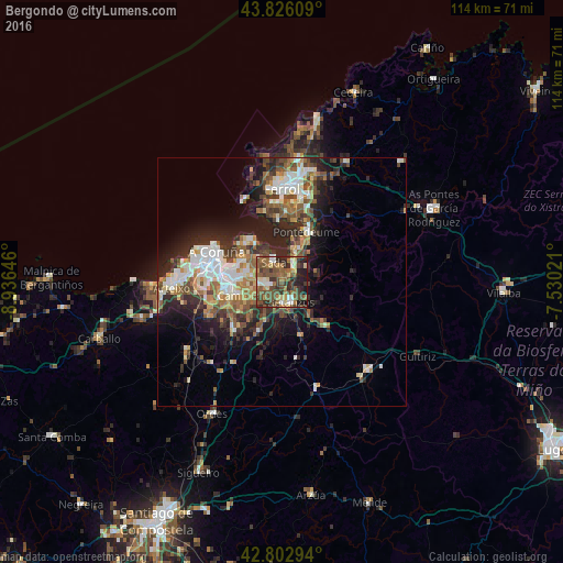
Analysis of Bergondo night lights 2016
Square area 10x10 km:
100  3.64%
3.64%
90-99 7.12%
80-89 5.91%
70-79 4.85%
60-69 11.52%
50-59 18.64%
40-49 15.61%
30-39 11.82%
20-29 13.94%
10-19 6.97%
0-9 0%
3.64%90-99
7.12%80-89
5.91%70-79
4.85%60-69
11.52%50-59
18.64%40-49
15.61%30-39
11.82%20-29
13.94%10-19
6.97%0-9
0%Square area 50x50 km:
100 2.93%
90-99 3.73%
80-89 1.75%
70-79 2.03%
60-69 3.12%
50-59 3.29%
40-49 3.42%
30-39 3.13%
20-29 6.61%
10-19 8.48%
0-9 61.52%
2.93%90-99
3.73%80-89
1.75%70-79
2.03%60-69
3.12%50-59
3.29%40-49
3.42%30-39
3.13%20-29
6.61%10-19
8.48%0-9
61.52%Clear (daylight) street map image can be seen on geolist.org.
Map coordinates:
43° 49' 33.9" North, 8° 56' 11.3" West
43° 19' 0" North, 8° 13' 60" West
42° 48' 10.6" North, 7° 31' 48.8" West
Some cities around Bergondo sort by population:
• Oleiros
7 km =4.3 mi,  285°
285°
• Culleredo
13 km =8.1 mi,  255°
255°
• Cambre
9.6 km =6 mi,  254°
254°
• Sada
4.8 km =3 mi,  335°
335°
• Betanzos
4.3 km =2.7 mi,  159°
159°
• Abegondo
11.8 km =7.3 mi,  200°
200°
• Ares
12.6 km =7.8 mi,  356°
356°
• Miño
4.6 km =2.9 mi,  36°
36°
3128190 (p: 6,446)
Sources (retrieved 2019-11-25):
» Earth at Night: Flat Maps 2012, 2016