Sada night lights from space
Night Light of Sada (Galicia) from space (Spain) Src. Average luminocity for 10x10km area is 51.0905% and for 50x50km: 20.6109%.
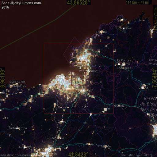
Analysis of Sada night lights 2016
Square area 10x10 km:
100  1.43%
1.43%
90-99 8.89%
80-89 6.83%
70-79 7.46%
60-69 12.54%
50-59 15.87%
40-49 6.98%
30-39 10.95%
20-29 24.44%
10-19 4.6%
0-9 0%
1.43%90-99
8.89%80-89
6.83%70-79
7.46%60-69
12.54%50-59
15.87%40-49
6.98%30-39
10.95%20-29
24.44%10-19
4.6%0-9
0%Square area 50x50 km:
100 2.95%
90-99 3.74%
80-89 1.81%
70-79 2.12%
60-69 3.31%
50-59 3.54%
40-49 3.81%
30-39 3.43%
20-29 7.4%
10-19 9.78%
0-9 58.11%
2.95%90-99
3.74%80-89
1.81%70-79
2.12%60-69
3.31%50-59
3.54%40-49
3.81%30-39
3.43%20-29
7.4%10-19
9.78%0-9
58.11%Clear (daylight) street map image can be seen on geolist.org.
Map coordinates:
43° 51' 55" North, 8° 57' 39.9" West
43° 21' 22.3" North, 8° 15' 28.7" West
42° 50' 34.1" North, 7° 33' 17.4" West
Some cities around Sada sort by population:
• A Coruña
11.3 km =7 mi,  278°
278°
• Oleiros
5.4 km =3.4 mi,  241°
241°
• Cambre
10 km =6.2 mi,  226°
226°
• Betanzos
9.1 km =5.7 mi,  157°
157°
• Bergondo
4.8 km =3 mi, 155°
• Mugardos
11.6 km =7.2 mi,  1°
1°
• Ares
8.3 km =5.2 mi,  8°
8°
• Miño
4.7 km =2.9 mi,  98°
98°
3111158 (p: 14,487)
Sources (retrieved 2019-11-25):
» Earth at Night: Flat Maps 2012, 2016