Chantada night lights from space
Night Light of Chantada (Galicia) from space (Spain) Src. Average luminocity for 10x10km area is 1.9864% and for 50x50km: 1.8052%.
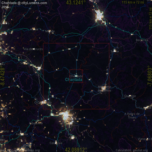
Analysis of Chantada night lights 2016
Square area 10x10 km:
 0.3%
0.3%90-99
0.91%80-89
0%70-79
0%60-69
0%50-59
0%40-49
0.61%30-39
0.61%20-29
0%10-19
1.21%0-9
96.36%Square area 50x50 km:
0.1%90-99
0.33%80-89
0.13%70-79
0.22%60-69
0.11%50-59
0.27%40-49
0.22%30-39
0.39%20-29
0.61%10-19
0.91%0-9
96.71%Clear (daylight) street map image can be seen on geolist.org.
Map coordinates:
43° 7' 26.8" North, 8° 28' 27.4" West
42° 36' 31.5" North, 7° 46' 16.1" West
42° 5' 20.8" North, 7° 4' 4.9" West
Some cities around Chantada sort by population:
• Ourense
31.2 km =19.4 mi,  194°
194°
• Lalín
28.5 km =17.7 mi,  281°
281°
• Monforte de Lemos
23.2 km =14.4 mi,  114°
114°
• O Carballiño
32 km =19.9 mi,  232°
232°
• Sarria
34.9 km =21.7 mi,  56°
56°
• Silleda
40.1 km =24.9 mi, 284°
• Castro
23.3 km =14.5 mi,  41°
41°
• Pereiro de Aguiar
29.4 km =18.3 mi,  184°
184°
3125212 (p: 9,339)
Sources (retrieved 2019-11-25):
» Earth at Night: Flat Maps 2012, 2016