Pereiro de Aguiar night lights from space
Night Light of Pereiro de Aguiar (Galicia) from space (Spain) Src. Average luminocity for 10x10km area is 32.6746% and for 50x50km: 6.1091%.
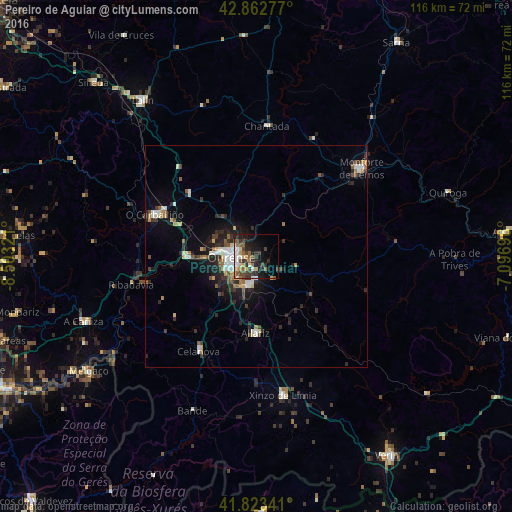
Analysis of Pereiro de Aguiar night lights 2016
Square area 10x10 km:
 4.92%
4.92%90-99
5.24%80-89
3.81%70-79
3.65%60-69
2.7%50-59
7.14%40-49
5.4%30-39
8.57%20-29
9.37%10-19
15.87%0-9
33.33%Square area 50x50 km:
0.77%90-99
1.02%80-89
0.57%70-79
0.6%60-69
0.52%50-59
0.84%40-49
0.92%30-39
1.11%20-29
2.38%10-19
3.45%0-9
87.82%Clear (daylight) street map image can be seen on geolist.org.
Map coordinates:
42° 51' 46" North, 8° 30' 11.6" West
42° 20' 42.9" North, 7° 48' 0.3" West
41° 49' 24.3" North, 7° 5' 49.1" West
Some cities around Pereiro de Aguiar sort by population:
• Ourense
5.3 km =3.3 mi,  259°
259°
• Monforte de Lemos
30.6 km =19 mi,  50°
50°
• O Carballiño
24.8 km =15.4 mi,  292°
292°
• Xinzo de Limia
31.9 km =19.8 mi,  168°
168°
• Chantada
29.4 km =18.3 mi,  4°
4°
• Celanova
24.9 km =15.5 mi,  210°
210°
• Ribadavia
29 km =18 mi, 257°
• Allariz
17.2 km =10.7 mi,  180°
180°
3113738 (p: 5,443)
Sources (retrieved 2019-11-25):
» Earth at Night: Flat Maps 2012, 2016