Silleda night lights from space
Night Light of Silleda (Galicia) from space (Spain) Src. Average luminocity for 10x10km area is 7.3848% and for 50x50km: 5.4719%.
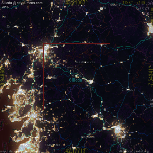
Analysis of Silleda night lights 2016
Square area 10x10 km:
 0%
0%90-99
1.21%80-89
1.52%70-79
1.21%60-69
1.36%50-59
1.67%40-49
0%30-39
0.61%20-29
2.42%10-19
0.61%0-9
89.39%Square area 50x50 km:
0.64%90-99
1%80-89
0.38%70-79
0.56%60-69
0.75%50-59
0.83%40-49
0.84%30-39
1.16%20-29
1.5%10-19
2.32%0-9
90.02%Clear (daylight) street map image can be seen on geolist.org.
Map coordinates:
43° 12' 38.4" North, 8° 56' 58.8" West
42° 41' 45.8" North, 8° 14' 47.5" West
42° 10' 37.7" North, 7° 32' 36.3" West
Some cities around Silleda sort by population:
• Santiago de Compostela
31.9 km =19.8 mi,  310°
310°
• Ribeira
17.1 km =10.6 mi,  289°
289°
• A Estrada
19.8 km =12.3 mi,  267°
267°
• Lalín
11.6 km =7.2 mi,  109°
109°
• Teo
21.6 km =13.4 mi, 286°
• Arzúa
27.5 km =17.1 mi,  16°
16°
• Cuntis
26.7 km =16.6 mi,  255°
255°
• Vedra
20.9 km =13 mi,  295°
295°
3108950 (p: 9,018)
Sources (retrieved 2019-11-25):
» Earth at Night: Flat Maps 2012, 2016