O Carballiño night lights from space
Night Light of O Carballiño (Galicia) from space (Spain) Src. Average luminocity for 10x10km area is 16.2968% and for 50x50km: 5.8748%.
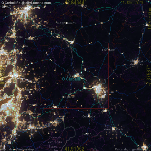
Analysis of O Carballiño night lights 2016
Square area 10x10 km:
 1.43%
1.43%90-99
3.97%80-89
1.27%70-79
2.86%60-69
0.95%50-59
1.75%40-49
0.79%30-39
2.54%20-29
3.17%10-19
7.3%0-9
73.97%Square area 50x50 km:
0.7%90-99
1%80-89
0.52%70-79
0.6%60-69
0.56%50-59
0.74%40-49
0.93%30-39
1.05%20-29
2.12%10-19
3.45%0-9
88.32%Clear (daylight) street map image can be seen on geolist.org.
Map coordinates:
42° 56' 54.4" North, 8° 46' 55.6" West
42° 25' 53.9" North, 8° 4' 44.4" West
41° 54' 37.9" North, 7° 22' 33.1" West
Some cities around O Carballiño sort by population:
• Ourense
20.6 km =12.8 mi,  120°
120°
• Lalín
25.6 km =15.9 mi,  353°
353°
• Chantada
32 km =19.9 mi,  52°
52°
• Silleda
32.4 km =20.1 mi,  334°
334°
• Celanova
32.6 km =20.3 mi,  161°
161°
• Ribadavia
16.8 km =10.4 mi,  198°
198°
• Pereiro de Aguiar
24.8 km =15.4 mi,  112°
112°
• Allariz
35.2 km =21.9 mi,  139°
139°
3126373 (p: 14,114)
Sources (retrieved 2019-11-25):
» Earth at Night: Flat Maps 2012, 2016