Sangolquí night lights from space
Night Light of Sangolquí (Pichincha) from space (Ecuador) Src. Average luminocity for 10x10km area is 90.2987% and for 50x50km: 34.4266%.
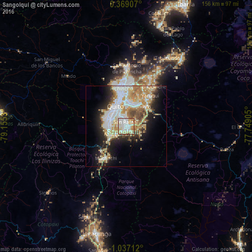
Analysis of Sangolquí night lights 2016
Square area 10x10 km:
 30.95%
90-99
30.3%80-89
18.4%70-79
12.55%60-69
6.06%50-59
0.87%40-49
0.87%30-39
0%20-29
0%10-19
0%0-9
0%Square area 50x50 km:
8.07%90-99
7.35%80-89
6.01%70-79
5.56%60-69
4.45%50-59
2.47%40-49
3.34%30-39
2.87%20-29
5.27%10-19
10.23%0-9
44.38%Clear (daylight) street map image can be seen on geolist.org.
Map coordinates:
0° 22' 8.7" North, 79° 9' 19.1" West
0° 20' 2.6" South, 78° 27' 7.8" West
1° 2' 13.6" South, 77° 44' 56.6" West
Some cities around Sangolquí sort by population:
• Quito
14.1 km =8.8 mi,  325°
325°
• Tutamandahostel
16 km =9.9 mi,  341°
341°
• Latacunga
69.3 km =43.1 mi,  195°
195°
• Otavalo
66.6 km =41.4 mi,  18°
18°
• Cayambe
53.9 km =33.5 mi,  39°
39°
• Machachi
23.4 km =14.5 mi,  213°
213°
• Pujilí
74.5 km =46.3 mi, 201°
• Cotacachi
73.6 km =45.7 mi, 16°
3651857 (p: 5,114)
Sources (retrieved 2019-11-25):
» Earth at Night: Flat Maps 2012, 2016