Cayambe night lights from space
Night Light of Cayambe (Pichincha) from space (Ecuador) Src. Average luminocity for 10x10km area is 48.5909% and for 50x50km: 14.9491%.
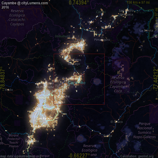

Analysis of Cayambe night lights 2016
Square area 10x10 km:
 3.46%
3.46%90-99
8.66%80-89
6.71%70-79
15.8%60-69
5.84%50-59
5.19%40-49
7.14%30-39
9.52%20-29
12.77%10-19
21.21%0-9
3.68%Square area 50x50 km:
0.85%90-99
2.04%80-89
2.14%70-79
2.88%60-69
3.5%50-59
1.4%40-49
2.47%30-39
2.92%20-29
4.37%10-19
8.76%0-9
68.67%Clear (daylight) street map image can be seen on geolist.org.
Map coordinates:
0° 44' 38.2" North, 78° 50' 54.1" West
0° 2' 27" North, 78° 8' 42.9" West
0° 39' 44.2" South, 77° 26' 31.6" West
Some cities around Cayambe sort by population:
• Quito
51.8 km =32.2 mi,  234°
234°
• Tutamandahostel
47.3 km =29.4 mi,  235°
235°
• Ibarra
34.7 km =21.6 mi,  4°
4°
• Otavalo
25.2 km =15.7 mi,  328°
328°
• Atuntaqui
33.3 km =20.7 mi,  346°
346°
• Cotacachi
31.8 km =19.8 mi,  335°
335°
• Pimampiro
45.1 km =28 mi,  30°
30°
• Sangolquí
53.9 km =33.5 mi,  219°
219°
3659578 (p: 26,582)
Sources (retrieved 2019-11-25):
» Earth at Night: Flat Maps 2012, 2016