Piñas night lights from space
Night Light of Piñas (El Oro) from space (Ecuador) Src. Average luminocity for 10x10km area is 21.79% and for 50x50km: 3.3744%.
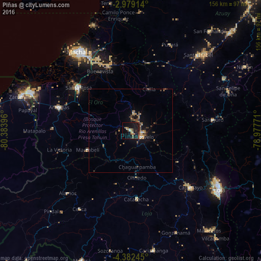
Analysis of Piñas night lights 2016
Square area 10x10 km:
100  1.3%
1.3%
90-99 0.43%
80-89 3.25%
70-79 3.68%
60-69 4.33%
50-59 2.38%
40-49 3.68%
30-39 1.08%
20-29 3.25%
10-19 41.56%
0-9 35.06%
1.3%90-99
0.43%80-89
3.25%70-79
3.68%60-69
4.33%50-59
2.38%40-49
3.68%30-39
1.08%20-29
3.25%10-19
41.56%0-9
35.06%Square area 50x50 km:
100 0.12%
90-99 0.14%
80-89 0.34%
70-79 0.72%
60-69 0.56%
50-59 0.57%
40-49 0.78%
30-39 0.61%
20-29 0.48%
10-19 3.41%
0-9 92.28%
0.12%90-99
0.14%80-89
0.34%70-79
0.72%60-69
0.56%50-59
0.57%40-49
0.78%30-39
0.61%20-29
0.48%10-19
3.41%0-9
92.28%Clear (daylight) street map image can be seen on geolist.org.
Map coordinates:
2° 58' 44.9" South, 80° 23' 2.3" West
3° 40' 51.9" South, 79° 40' 51" West
4° 22' 56.8" South, 78° 58' 39.8" West
Some cities around Piñas sort by population:
• Machala
56.3 km =35 mi,  326°
326°
• Pasaje
41.9 km =26 mi,  340°
340°
• Santa Rosa
40.3 km =25 mi,  309°
309°
• Catamayo
49.3 km =30.6 mi,  133°
133°
• Zaruma
7.8 km =4.8 mi,  98°
98°
• Catacocha
41.1 km =25.5 mi,  175°
175°
• Portovelo
7.9 km =4.9 mi,  124°
124°
• Celica
56 km =34.8 mi,  213°
213°
3653130 (p: 16,981)
Sources (retrieved 2019-11-25):
» Earth at Night: Flat Maps 2012, 2016