’Aïn Benian night lights from space
Night Light of ’Aïn Benian (Tipaza) from space (Algeria) Src. Average luminocity for 10x10km area is 57.5035% and for 50x50km: 32.3567%.
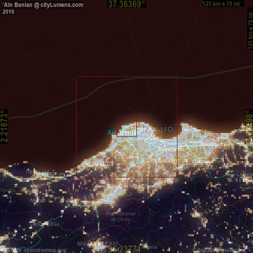

Analysis of ’Aïn Benian night lights 2016
Square area 10x10 km:
 19.58%
90-99
17.66%80-89
5.07%70-79
6.82%60-69
1.57%50-59
0.35%40-49
2.8%30-39
6.82%20-29
15.56%10-19
16.61%0-9
7.17%Square area 50x50 km:
8.78%90-99
7.29%80-89
4.54%70-79
5.15%60-69
5.27%50-59
3.03%40-49
2.12%30-39
2.55%20-29
4.48%10-19
4.4%0-9
52.4%Clear (daylight) street map image can be seen on geolist.org.
Map coordinates:
37° 21' 49.3" North, 2° 13' 7.4" East
36° 48' 10" North, 2° 55' 18.7" East
36° 14' 15.8" North, 3° 37' 29.9" East
Some cities around ’Aïn Benian sort by population:
• Algiers
16.7 km =10.4 mi,  117°
117°
• Baraki
21.7 km =13.5 mi,  134°
134°
• Birkhadem
15 km =9.3 mi, 130°
• Kolea
22.8 km =14.2 mi,  216°
216°
• Cheraga
5.1 km =3.2 mi,  139°
139°
• Douera
14.9 km =9.3 mi,  172°
172°
• Zeralda
12.4 km =7.7 mi,  214°
214°
• Saoula
14.3 km =8.9 mi, 140°
2508275 (p: 31,102)
Sources (retrieved 2019-11-25):
» Earth at Night: Flat Maps 2012, 2016