Yamasá night lights from space
Night Light of Yamasá (Monte Plata) from space (Dominican Republic) Src. Average luminocity for 10x10km area is 5.7066% and for 50x50km: 6.3698%.
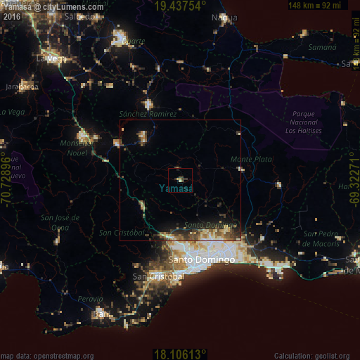
Analysis of Yamasá night lights 2016
Square area 10x10 km:
 0%
0%90-99
0.41%80-89
0.41%70-79
1.86%60-69
0.21%50-59
0.83%40-49
0.21%30-39
3.93%20-29
1.65%10-19
2.48%0-9
88.02%Square area 50x50 km:
0.27%90-99
1.03%80-89
0.69%70-79
0.73%60-69
1.14%50-59
0.96%40-49
1.28%30-39
1.95%20-29
1.92%10-19
3.16%0-9
86.87%Clear (daylight) street map image can be seen on geolist.org.
Map coordinates:
19° 26' 15.1" North, 70° 43' 44.3" West
18° 46' 23.3" North, 70° 1' 33" West
18° 6' 22.1" North, 69° 19' 21.8" West
Some cities around Yamasá sort by population:
• Santo Domingo Oeste
30.5 km =19 mi,  174°
174°
• Villa Altagracia
18.9 km =11.7 mi,  233°
233°
• Sabana Grande de Boyá
31 km =19.3 mi,  52°
52°
• Monte Plata
25.7 km =16 mi,  81°
81°
• Cristo Rey
31.9 km =19.8 mi,  162°
162°
• La Agustina
31.9 km =19.8 mi, 162°
• Piedra Blanca
31.6 km =19.6 mi,  284°
284°
• Esperalvillo
4.8 km =3 mi,  347°
347°
3491796 (p: 11,595)
Sources (retrieved 2019-11-25):
» Earth at Night: Flat Maps 2012, 2016