La Agustina night lights from space
Night Light of La Agustina (Nacional) from space (Dominican Republic) Src. Average luminocity for 10x10km area is 93.8347% and for 50x50km: 26.1827%.
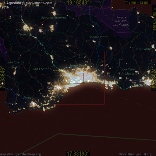
Analysis of La Agustina night lights 2016
Square area 10x10 km:
 48.35%
90-99
31.2%80-89
8.26%70-79
7.64%60-69
2.07%50-59
0.83%40-49
1.45%30-39
0.21%20-29
0%10-19
0%0-9
0%Square area 50x50 km:
6.01%90-99
5.82%80-89
2.8%70-79
2.8%60-69
3.78%50-59
1.86%40-49
3.33%30-39
4.72%20-29
6.48%10-19
9.54%0-9
52.85%Clear (daylight) street map image can be seen on geolist.org.
Map coordinates:
19° 9' 55.7" North, 70° 38' 11.3" West
18° 30' 0" North, 69° 55' 60" West
17° 49' 54.9" North, 69° 13' 48.8" West
Some cities around La Agustina sort by population:
• Santo Domingo
5.3 km =3.3 mi,  125°
125°
• Bella Vista
5.1 km =3.2 mi,  194°
194°
• Villa Francisca
5 km =3.1 mi,  112°
112°
• Villa Consuelo
4 km =2.5 mi,  117°
117°
• Cristo Rey
0 km =0 mi,  0°
0°
• San Carlos
4 km =2.5 mi, 117°
• La Julia
3.7 km =2.3 mi,  180°
180°
• Ensanche Luperón
3.5 km =2.2 mi,  90°
90°
3503735 (p: 10,457)
Sources (retrieved 2019-11-25):
» Earth at Night: Flat Maps 2012, 2016