Esperalvillo night lights from space
Night Light of Esperalvillo (Monte Plata) from space (Dominican Republic) Src. Average luminocity for 10x10km area is 4.7554% and for 50x50km: 2.7749%.
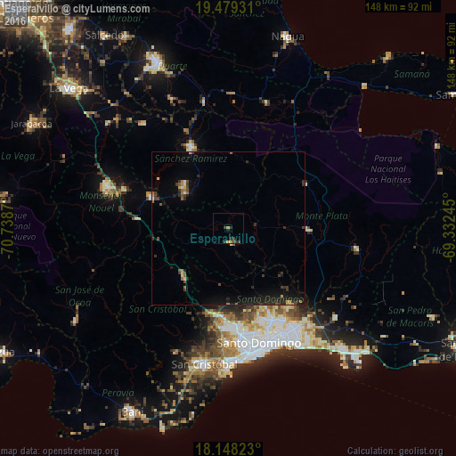
Analysis of Esperalvillo night lights 2016
Square area 10x10 km:
 0%
0%90-99
0%80-89
0%70-79
1.95%60-69
0.65%50-59
0%40-49
0.22%30-39
4.55%20-29
2.16%10-19
0.87%0-9
89.61%Square area 50x50 km:
0.07%90-99
0.12%80-89
0.27%70-79
0.24%60-69
0.39%50-59
0.3%40-49
0.37%30-39
1.04%20-29
1.01%10-19
2.42%0-9
93.78%Clear (daylight) street map image can be seen on geolist.org.
Map coordinates:
19° 28' 45.5" North, 70° 44' 19.3" West
18° 48' 54.3" North, 70° 2' 8.1" West
18° 8' 53.6" North, 69° 19' 56.8" West
Some cities around Esperalvillo sort by population:
• Santo Domingo Oeste
35.2 km =21.9 mi,  173°
173°
• Cotuí
29 km =18 mi,  335°
335°
• Villa Altagracia
21.3 km =13.2 mi,  222°
222°
• Sabana Grande de Boyá
29.3 km =18.2 mi,  60°
60°
• Monte Plata
26.5 km =16.5 mi,  91°
91°
• Cristo Rey
36.7 km =22.8 mi,  162°
162°
• Yamasá
4.8 km =3 mi, 167°
• Piedra Blanca
29.8 km =18.5 mi,  276°
276°
3505861 (p: 5,445)
Sources (retrieved 2019-11-25):
» Earth at Night: Flat Maps 2012, 2016