Río Grande night lights from space
Night Light of Río Grande (Puerto Plata) from space (Dominican Republic) Src. Average luminocity for 10x10km area is 0.1364% and for 50x50km: 11.8592%.
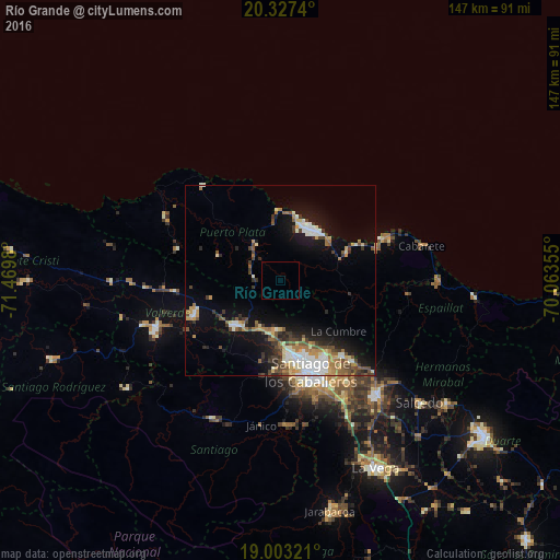

Analysis of Río Grande night lights 2016
Square area 10x10 km:
 0%
0%90-99
0%80-89
0%70-79
0%60-69
0%50-59
0%40-49
0%30-39
0%20-29
0%10-19
0%0-9
100%Square area 50x50 km:
1.72%90-99
2.13%80-89
1.26%70-79
1.23%60-69
1.92%50-59
1.32%40-49
1.88%30-39
2.05%20-29
1.9%10-19
7.36%0-9
77.22%Clear (daylight) street map image can be seen on geolist.org.
Map coordinates:
20° 19' 38.6" North, 71° 28' 11.3" West
19° 40' 0" North, 70° 46' 0" West
19° 0' 11.6" North, 70° 3' 48.8" West
Some cities around Río Grande sort by population:
• Santiago de los Caballeros
25 km =15.5 mi,  163°
163°
• Puerto Plata
16.3 km =10.1 mi,  30°
30°
• Esperanza
24.6 km =15.3 mi,  248°
248°
• Villa Bisonó
16.2 km =10.1 mi,  224°
224°
• Tamboril
25.9 km =16.1 mi,  141°
141°
• Monte Llano
19.1 km =11.9 mi,  66°
66°
• Villa González
14.2 km =8.8 mi,  189°
189°
• Imbert
11.7 km =7.3 mi,  325°
325°
3493769 (p: 20,154)
Sources (retrieved 2019-11-25):
» Earth at Night: Flat Maps 2012, 2016