Imbert night lights from space
Night Light of Imbert (Puerto Plata) from space (Dominican Republic) Src. Average luminocity for 10x10km area is 5.3905% and for 50x50km: 6.2574%.
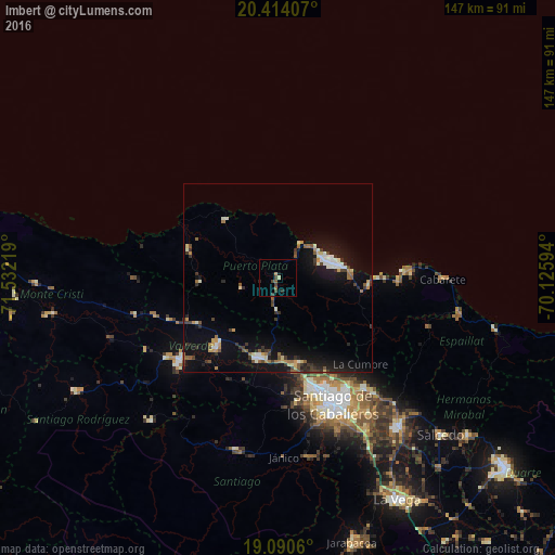
Analysis of Imbert night lights 2016
Square area 10x10 km:
 0%
0%90-99
0.21%80-89
0.62%70-79
0.62%60-69
0.83%50-59
1.03%40-49
2.07%30-39
2.27%20-29
1.03%10-19
0.83%0-9
90.5%Square area 50x50 km:
0.6%90-99
0.84%80-89
0.52%70-79
0.59%60-69
0.85%50-59
0.73%40-49
0.75%30-39
1.52%20-29
1.06%10-19
6.15%0-9
86.39%Clear (daylight) street map image can be seen on geolist.org.
Map coordinates:
20° 24' 50.7" North, 71° 31' 55.9" West
19° 45' 13.4" North, 70° 49' 44.6" West
19° 5' 26.2" North, 70° 7' 33.4" West
Some cities around Imbert sort by population:
• Puerto Plata
15.4 km =9.6 mi,  73°
73°
• Esperanza
24.9 km =15.5 mi,  220°
220°
• Villa Bisonó
21.7 km =13.5 mi,  193°
193°
• Río Grande
11.7 km =7.3 mi,  145°
145°
• Monte Llano
24.2 km =15 mi,  95°
95°
• Villa González
24.1 km =15 mi,  169°
169°
• Sosúa
32.3 km =20.1 mi,  90°
90°
• Laguna Salada
29.1 km =18.1 mi,  246°
246°
3504332 (p: 8,024)
Sources (retrieved 2019-11-25):
» Earth at Night: Flat Maps 2012, 2016